|
This page may contain links that result in small commissions to keep this free site up and running.

Welcome Guest! Registering and/or logging in will remove the anchor (bottom) ads. It's Free!
To participate in the forum you must log in or register.
| Author |
Replies: 28 / Views: 24,833 |
|
|
|
Pillar Of The Community
Canada
1084 Posts |
|
|
Heading west the Nagogami Airfield was the next link in the Trans-Canada Airway system. As far as I can determine it was named after nearby Nagogami Station (also spelled "Nagagami") on the the old National Transcontinental/Canadian National Railway line, which was closed down decades ago. The station, in turn, was probably named after the Nagagami River, which, oddly enough, is two stations back along the old rail bed. On a personal note I capsized a canoe on the Nagagami and luckily managed to retrieve it without drowning. As far as I can determine the Nagogami Station was located on the west side of the Pitopiko River. I do not have any old aerial photography for this site nor have I seen it from the air. Although the terrain conditions don't look great the Nagogami Airfield may have been located on the south side of the tracks on the east side of the river. Below is my rendition of what it might have looked like or, possibly, was intended to look like based on barely perceptible intermittent cut lines on the Google Map image: Postulated Location of Abandoned Nagogami TCA Airfield  It's possible that the only strip that was completed was the one that parallels the railway tracks. |
Send note to Staff
|
| Edited by cynical - 12/18/2012 07:09 am |
|
|
Pillar Of The Community
Canada
1084 Posts |
|
|
Roughly 27 miles west of Nagogami is the abandoned TCA Pagwa Airfield. There is not much there now but over the years the little community of Pagwa had a few lives. Located on the Pagwachuan River (hence its name), it served as a jumping-off place for anyone wanting to reach the few downstream settlements along the Albany River system and ultimately Fort Albany on James Bay. Scows were built over the winter at Pagwa to ferry supplies downstream to the Hudson Bay Company Fort Albany Post as soon as the ice went out. Furs would be brought back upstream to be loaded on trains at Pagwa Station. This activity ended, however, when the railway line was constructed from Cochrane to Moosonee on James Bay. Pagwa's life revived again in the 1930s when the work camp was set up to construct the TCA airfield. As with many other of the airfields in the TCA system its operational life was rather short. However, it would be resurrected to play a supporting role related to the Pagwa Radar Base that was constructed and manned by the United States Air Force (USAF) in the early 1950s as part of the Cold War's Pinetree Line. Two of the air strips were resurrected and maintained during this period. This base was transferred to the Royal Canadian Air Force (RCAF) in 1963. It had a short life after that as the base was closed in December, 1966 and the airfield has been abandoned ever since. Given the site's history one would think that there are military covers tucked away in collections somewhere. The Pagwa River Post Office opened in 1928 and closed in 1970. RCAF Pagwa Post Office opened on July 22, 1964 and closed November 30, 1966. The Pagwachuan River is not shown on the image below but is roughly one mile to the east. When I was there the only access was along the rail bed or to canoe downstream from the Trans-Canada Highway. It is now accessible by bush roads as much of the nearby area has recently been harvested. Abandoned TCA Pagwa Airfield  |
Send note to Staff
|
| Edited by cynical - 12/21/2012 4:37 pm |
|
|
Pillar Of The Community
Canada
1084 Posts |
|
|
Still heading west the next airfield in the system was at Ogahalla, Ontario. Wiki says that Ogahalla is: Quote: on a now abandoned portion of the Canadian National Railway main line originally constructed as the National Transcontinental Railway main line between the railway points of Lynx to the west and Blanche to the east, 4 kilometres (2 mi) west of where the line crossed the Kenogami River. It is also on Ogahalla Creek, part of the James Bay drainage basin, which flows via the Atikasibi River to the Kenogami River.
A now abandoned airfield, created by the Department of National Defence in the mid-1930s in part using 22,632 person-days of unemployment relief labour, lies to the north of the place. A Frontier College instructor was located at the construction camp. The airfield became part of a string of emergency landing sites for Trans-Canada Air Lines (today Air Canada) to support their transcontinental flight operations. Today the Ogahalla Airfield is difficult to locate on Google Maps because the site has been over-taken by forest. What I believe its approximate configuration and location was is shown on the Google Maps image below: Abandoned TCA Ogahalla Airfield  |
Send note to Staff
|
|
|
Pillar Of The Community
Canada
1084 Posts |
|
|
The next airfield on our journey west was located on the south side of the tracks at the former railway hamlet of Grant. According to Wiki, Grant came into being in 1913 with the construction of the National Transcontinental Railway (NTR), which stretched from Moncton, New Brunswick to Winnipeg, Manitoba. Grant, which is where the last spike was driven in the railway's construction, became a divisional point between Armstrong to the west and Hearst to the east. Grant, however, soon lost its divisional importance following the 1924 completion of the Longlac-Nakina Cut-Off, which occurred when the Canadian National Railway assumed control of both the National Transcontinental Railway and the Canadian Northern railway. The short cut-off line was built to connect the two lines and Nakina became the new divisional point. That portion of the NTR line east of Nakina became a secondary line with reduced traffic and the buildings at Grant were moved by rail 16 miles west to Nakina. Roughly a decade later Grant re-awakened somewhat when a relief work camp was established to construct the Grant Airfield. Its single strip became one of the string of emergency landing sites in the cross-country Trans-Canada Airway system used by Trans-Canada Air Lines to initially haul mail and shortly thereafter passengers. Abandoned TCA Grant Airfield  |
Send note to Staff
|
|
|
Pillar Of The Community
Canada
1084 Posts |
|
|
Just 16 miles west of the Grant Airfield was the Nakina Airfield, a portion of which still exists today albeit much improved. Nakina came into being when the CNR built a short stretch of track north from Longlac to join with the old National Transcontinental (NTR) system. The Longlac-Nakina Cut-off can be seen coming up from the bottom of the image below while the old NTR rail bed is oriented east-west. Two of the three original strips have been abandoned but the third has been extended and paved to form the Nakina Airport's 9-27 Runway. I have marked a spot a few miles east of the airport where I believe a four tower, low-frequency radio beacon may have existed to guide aircraft. My only evidence for stating this is having seen a small symbol showing a four-tower configuration on an old mining claims map as well as on an old National Topographic System (NTS) map (Map 42L/2) shown below. Trans-Canada Airway System (TCA) Nakina Airfield  Nakina TCA Landing Strips NTS Map 42L/2  The Collections Canada website has many photos showing the relief camp itself as well as of activities pertaining to clearing and construction of the airfield. Below is a cropped image of one such photo showing workers preparing stumps for burning in May 1935. Nakina TCA Relief Camp Workers Preparing Stumps to Burn May 1935  In the cropped photo below Nakina residents have donned their cross-country skis to meet one of Canadian Airways' Junkers-W34, in this case CF-AQV, on Strip#1 in April 1936. It would end its career in September, 1939, when it clipped some tree tops while trying to fly under the weather south of Gold Pines near Ear Falls at the western end of Lac Seul. Canadian Airways Junkers-W34 CF-AQV on TCA Nakina Airfield April 1936  Aviation buffs with a philatelic bent will recognize this plane's stable mate, CF-AQW, which is depicted on the semi-official air post stamps of Canadian Airways Ltd (Canada Scott#CL51 and Canada Scott#CL52) issued in 1932. Canadian Airways Ltd (1932 Canada Scott#CL51)  The relief camps involved in constructing airfields were administered by the Department of National Defense (DND) until the program ended in 1936 at which time the Department of Transport took over (DOT). During that initial construction phase there were Royal Canadian Army (RCA) personnel at each of the camps over-seeing construction and this typically included a military doctor. I believe the two philatelic first flight covers shown below and previously posted on Stamp Community Forum (SCF) reflect this military presence at Nakina. First Flight Cover-Nakina Return Address Major CJ Houghton RCA 1935  First Flight Cover-Nakina Return Address Major CJ Houghton RCA 1935  My tentative suggestion that a four-tower radio beacon existed a few miles east of the airfield has to do with Nakina having been one of five radar sites that the United States Army Air Forces (USAAF 671 Signals Co.) established in northern Ontario during WW2 that pre-dated the Pinetree Radar Line. The other sites were Armstrong to the west and Hearst, Kapuskasing and Cochrane to the east. Their purpose was to protect the Sault Ste. Marie canal locks from a Pearl Harbour-like attack from Hudson Bay. I don't know where this site was located at Nakina other than that there was a living area for US personnel on the west side of town and that the radar site was supposedly on the east side of Highway 584, which terminates at Nakina. The base was short-lived in that construction began in 1942 and the site was closed in 1944 after re-consideration of the threat level. Below is a 1943 aerial photograph of the Nakina area that shows the airfield during this period. 1943 Aerial Photo of Nakina and the TCA Airfield  |
Send note to Staff
|
| Edited by cynical - 01/08/2013 8:44 pm |
|
|
Pillar Of The Community
Canada
1084 Posts |
|
|
The next stop on our journey west to the Ontario-Manitoba border is the long-abandoned Kowkash Airfield, sometimes referred to as the Kowkash Intermediate Aerodrome. Like other communities along the railway line Kowkash has had its ups and downs depending on the vagaries of the railway and timber industry. Its post office history reflects this in that it first opened in 1916 and closed in 1927 but re-opened 20 years later in 1947 and closed again in 1961. Although I have always had my eyes peeled for a Kowkash postmark/cancellation I have yet to see one. As with the others the airfield was cleared by relief camp workers and the Collections Canada web site has an array of pictures depicting this operation. The airfield was located on the south side of the tracks a short distance west of the Kowkash Station. Trans-Canada Airway System (TCA) Kowkash Airfield  |
Send note to Staff
|
|
|
Pillar Of The Community
Canada
1084 Posts |
|
|
Moving west from Kowkash our flight west takes us over the long-abandoned Lamaune Airfield. This emergency field is difficult to discern having been taken over by vegetation. It's sad in a way because 43661 man-days were spent constructing it as part of the unemployment relief program.  As our TCA plane flies over the Lamaune emergency strips one can picture the flight crew giving preparatory instructions to passengers for landing at the next refueling stop just 30 miles ahead. Remember that it is the airfield system that follows the railway track. The planes are following radio beacons (morse code transmissions received through earphones). In parts of the Ontario portion of the route the tracks and the radio beams may be coincident but this is certainly not the case between the Lamaune Airfield and our next one. Through this section the track is forced to make major directional changes to avoid large peatlands, drainage systems and landform obstructions. In the latter instance (e.g. Ferland, Haystack Mountain) the track can be seen to change direction to pass through promontory gaps. |
Send note to Staff
|
|
|
Pillar Of The Community
Canada
1084 Posts |
|
|
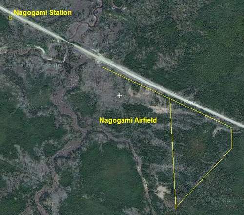
We have flown over numerous TCA emergency airfields (aerodromes) since leaving Malton and have made brief fuel stops at North Bay (a "cacheted" mail stop) and another at Kapuskasing (not a "cacheted" stop). I mentioned in the last post that probably over Lamaune or shortly thereafter staff would be advising passengers to prepare for landing at their next fuel stop, namely Wagaming, which may have been somewhat of a surprise for them. I will let The NetLetter#940 (Sep 16, 2006) tell part of the story: Quote: A TCA schedule dated Nov 1,1939 listed a strange sounding airport "WAGAMING", that most people wouldn't have heard of yet it was a stop on the Trans Continental route.
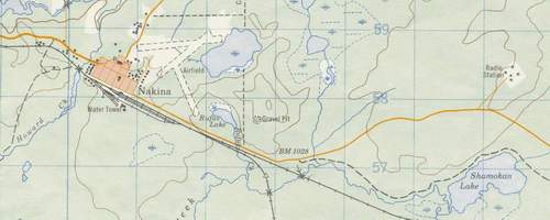
Where is it - about halfway between Winnipeg and Kapuskasing on the CNR rail line. First staffed with TCA employees in 1939 as it became an essential fuel stop on the trans-Canada route of TCA. By 1940, the airport name was changed to Armstrong, the little railroad town 8 miles west of the airport. It was not shown on later timetables so passengers were always surprised when they had to buckle up for a landing on this route. Flight #1 westbound dep at 0320 and Flight #2 Eastbound dep at 0641. I guess it was all midnight shifts for the staff. By 1945 the staff had increased to 12 but by Ju1 1947, with the newer aircraft, the station was closed down.
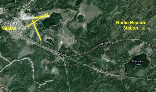
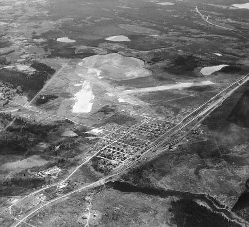
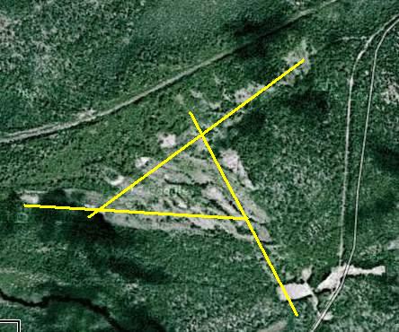
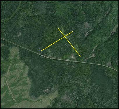
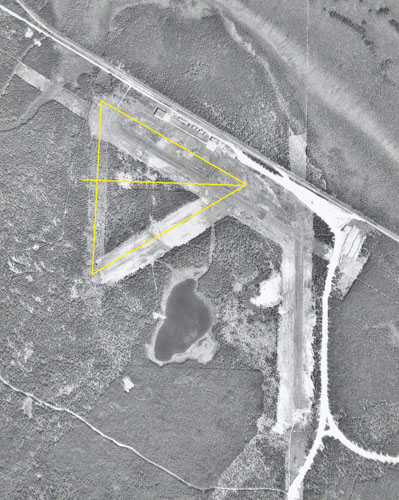
Below is my rendition of what the original runway configuration looked like superimposed on an aerial photograph taken in 1975 showing a much improved airport aligned with the CNR tracks. In the old days pilots had to keep a lookout for Woodland Caribou wandering across the strips. The caribou had a seasonal route between the airfield and the Lake Nipigon Islands where they would go for calving season. There has been talk recently of upgrading this airport. Trans-Canada Airway System (TCA) Wagaming (Armstrong) Airfield  In 1939 and subsequent flights the pilot and co-pilot would be looking for the strips represented by my yellow lines. On the night of February 6, 1941, for whatever reason, they missed the strips. The following is an abbreviated version of the Winnipeg Free Press description of the event: Quote: AIRLINER WRECKED OUTSIDE ARMSTRONG. Twelve persons, nine of them passengers and three crew members, were killed early Thursday morning when a Winnipeg-bound T.C.A. airliner crashed in the dense bush country one mile south of Armstrong, Ont. Six of the dead were Winnipeg residents. The crash came shortly after 3:47 a.m., as the plane attempted an emergency landing at the Armstrong airport. It was one of the worst aviation tragedies in Canadian history, and the first involving Trans-Canada Airlines. The dead are:
Captain W. E. TWISS, Winnipeg, formerly of Vancouver. First Officer C. E. LLOYD, Winnipeg, formerly of Ottawa. MISS M. G. MAYNE, stewardess, Winnipeg. Passengers: MRS. R. D. CARTER, Vancouver. E. MALONE, Toronto. F. W. F. GASSTON, Hudson's Bay Company, Winnipeg. H. MOSS, Toronto. Prof. ROBERT McQUEEN, Winnipeg. Lt. Cmdr. H. H. HARLOWE, Ottawa. E. C. MANNING, Victoria. F. J. FREER, Great-West Life Assurance Company, Winnipeg. I. E. DAVIDSON, Vancouver.
Ground crews at Armstrong, who waited in vain for the big plane to come into the field after its radio message saying it was landing, raised the alarm shortly after 4 a.m., and Air Line officials in Winnipeg were notified immediately.
Carrying D. A. Colyer, T.C.A. vice-president; R. F. GEORGE, superintendent of flight operation; H. H. KENYON, assistant to the general superintendent, and E. W. STULL, assistant superintendent of maintenance, the rescue plane left Stevenson field at 4:45 a.m. They arrived at Armstrong at 7:25 a.m.
Two hours later, after flying in widening circles about the air field, the wreckage was spotted. The plane had apparently overshot its mark and landed one mile south of the north-south runway of the field. Headed by a doctor and Red Cross nurses, a rescue party cut its way slowly through the deep snow to the site to find all aboard the plane dead. An immediate investigation has been ordered and an inquest will open at Armstrong this evening. Earlier in the day, department of transport officials had ruled out the possibility of engine trouble.
The plane left North Bay at 10:15 p.m. and arrived at Armstrong on schedule. It had sufficient gas for three more hours' flying at this point. The only warning received by the Armstrong airport officials was Capt. TWISS' brief message he was coming in to land. After that there was silence and airmen in the city speculated the plane's radio may have gone dead after its last contact.
While the wild terrain of northern and northwestern Ontario is better suited for ski and float equipped planes, T.C.A. has minimized this hazard by establishing a string of emergency bases.....strung along T.C.A.'s trans-continental route. The national air lines operations sheet shows a clean record since inauguration of a trans-continental passenger service, April 1, 1939. Guided by experienced fliers and numerous radio operators across the country, the big silver passenger planes have a perfect score of no crack-ups since then.
On April 1, 1940, T.C.A. marked its first year of operating Montreal-Toronto-Vancouver scheduled flights. Its safety record up to that time paralleled that of United States Airlines which a few days before had concluded a year of operations without fatalities. Opening the second year of the trans-continental route, T.C.A. doubled its service with two planes a day flying each way. Previously, only one plane a day each way made the flights.
Flying conditions at Armstrong were considered generally good when the crash took place with a ceiling of 1,200 feet and a visibility of one mile and a half. Light snow was falling.
First word of the disaster reached the city as Winnipeggers went to work. Then there was a long silence, broken with rumors of the plane reported first at Savant Lake, 70 miles east of Armstrong, followed by another that five persons had died. It was not untill noon that air line officials finally confirmed that rescue parties had found all aboard the 14-passenger Lockheed dead.
|
Send note to Staff
|
|
|
New Member
United States
3 Posts |
|
|
Pillar Of The Community
Canada
1084 Posts |
|
|
Joe: Great cover. There were so many philatelic covers for the event that I find myself always checking ebay for covers dated the next day (March 2). I would imagine that covers from or to the communities of Armstrong and Kapuskasing must be a great find given that they were not part of the postal cachet program. I remember someone connected with the Armstrong railway station operations saying that it was ironic that the Armstrong RPO operation/hammer outlasted the airmail one. |
Send note to Staff
|
|
|
Pillar Of The Community
Canada
1084 Posts |
|
|
......reporting back to say that I have been unable to find a March 2 cover. While doing so I got involved in Flight Simulator (FSX)and "flew" the route stopping at the airfields that have survived. |
Send note to Staff
|
|
|
Pillar Of The Community
Canada
1084 Posts |
|
|
Noticed this in a Sparks 2014 catalogue and thought I would include it here as it relates to the post above regarding the TCA crash at the Armstrong Airport.  |
Send note to Staff
|
|
|
New Member
Canada
1 Posts |
|
|
It is very interesting to learn about the airfields that were constructed for the Trans Canada Airway. I am a private pilot and still use many of these airfields (Muskoka, Emsdale, South River, North Bay). I am interesting in learning more about the airfields that made up the airway right across the country. Is anyone aware of the best source of information? |
Send note to Staff
|
|
Replies: 28 / Views: 24,833 |
|
|
To participate in the forum you must log in or register. | |

Disclaimer: While a tremendous amount of effort goes into ensuring the accuracy of the information contained in this site, Stamp Community assumes no liability for errors. Copyright 2005 - 2026 Stamp Community Family - All rights reserved worldwide. Use of any images or content on this website without prior written permission of Stamp Community or the original lender is strictly prohibited.
Privacy Policy / Terms of Use Advertise Here
|
| Stamp Community Forum |
© 2007 - 2026 Stamp Community Forums |
| It took 0.2 seconds to lick this stamp. |
 |
|
|
|