| Author |
 Replies: 29 / Views: 5,643 Replies: 29 / Views: 5,643 |
|
|
|
Pillar Of The Community
United States
2423 Posts |
|
|
Valued Member
Australia
283 Posts |
|
|
Hi Scotzm
OK no worries. Thanks for all your help anyway and we will give a bit of a plug for StampCommunities as acknowledgement.
Regards.
Ron and Eunice. |
Send note to Staff 
|
|
|
Valued Member
Australia
283 Posts |
|
|
Hi KGB
Well, you read the thread and took the trouble to answer and put your ideas, that's something..
Will do as we advised Scotzm and mention StampCommunity.
Will let you know when it is on the site.
Thanks
Ron and Eunice |
|
Send note to Staff
|
|
|
Moderator

United States
12330 Posts |
|
|
Interesting thread, thanks all who replied. As I read through it I could not help but wonder how weather may have impact the mail delivery during this era. Heavy rain may cause flooding and made some road impassable, bad spring may have impacted the ability to maintain healthy horses. I checked out this site, http://www.pascalbonenfant.com/18c/weather.html which indicates that the spring of 1837 had set many records for this area (wet snow in April!); but I did not see anything that mentioned rainfall amounts that might have followed in June. I am not familiar with the road system in this area at that time, were there flood plains or low laying roads that had to be navigated on this route? Don |
|
Send note to Staff
|
|
|
Pillar Of The Community
Germany
1714 Posts |
|
|
This web site is very useful regarding the old roads of Scotland around the time of the cover posted by Penguins. The maps pre-date the first stamps so would show the roads and distances used to calculate the postage rates that were in force from 1812 - 1839 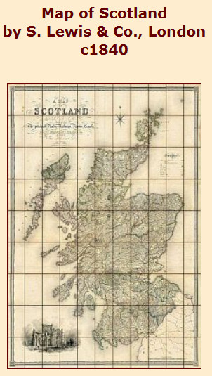 http://mapco.net/scotland/scotland.htm http://mapco.net/scotland/scotland.htmEach section of the Scotland map is click-able to show a detailed version of that particular area. The map is copyrighted so only fair use is in force so it should be referenced as source if you use it online etc and, of course,you cannot copy it for commercial use for instance. |
|
Send note to Staff
|
|
|
Pillar Of The Community
Germany
1714 Posts |
|
|
...." the road system in this area at that time, were there flood plains or low laying roads that had to be navigated on this route? "
Lots of roads at that time were maintained by Trusts set up for that purpose. The revenue for those roads came from the toll payments from just about anyone that passed along that road... horses, sheep, wagons , carts etc ... sometimes toll-gates and therefore payments had to be made every ten miles or so (sometimes more, sometimes less). Originally the Mail was excluded from paying but this was changed to help upgrade those roads and a charge of one halfpenny per letter was introduced. I believe 1937 was, indeed, a particularly bad year for rain etc and there were reports of bridges being washed away. In the main, Scottish roads followed the contours of the land to save time, effort and money. Building on top of rock was sensible in one way but did leave many roads undulating and not straight. Of course the valleys and flat areas had to be done differently but this was the time of two Scottish engineers, Macadam and Telford, who became world famous for their techniques in road engineering. |
|
Send note to Staff
|
|
|
Valued Member
Australia
283 Posts |
|
|
Hello all,
Further to Scotzm's comments, check this link on our website to find out about the road system and building the roads etc this is part of the information we have to go with our 40 letters written by a commercial traveler in England during the time 1828-1833. They are amazing evidence of life on the road at that time, explaining about the roads, the inns, the postage and accounting etc.
-/webgil/trnsport.html
We put the letters into a book format, and then into webpage format so that they could be accessed online. This is the link to the introduction and the first two letters
-/ontheroad/otrd1.html
For anyone interested in life in England/Scotland from 1666-1840 we have a heap of old letters on our site with some very interesting contents. Our site is purely for information, no adverts or jumping kangaroos <grin> Hope you find something of interest.
-/
Regards
Ron and Eunice
|
|
Send note to Staff
|
|
|
Pillar Of The Community
Germany
1714 Posts |
|
|
Looking at my oldies, I came across this one which has an Edinburgh, Langholm, Carlisle connection although at a slightly later date than the original posting by Penguins. Posted in Edinburgh (Hanover Street) January 15th 1857 and going to Alex Stevenson in Langholm. The transit markings on the back show it went via Carlisle then back up the road to Langholm. 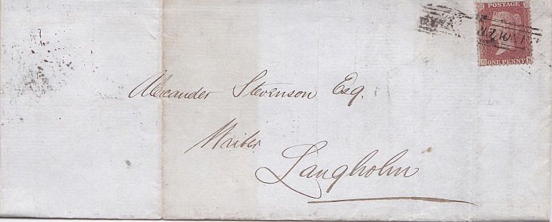 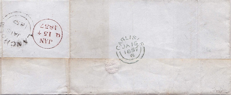 |
|
Send note to Staff
|
|
|
Valued Member
Australia
283 Posts |
|
|
That's great, many thanks for that.
Although later than the one we queried at least it shows that it could have happened that way.
Would you object if we used the scan of the reverse of the cover to go with our image of the letter?
Best regards
Ron and Eunice. |
|
Send note to Staff
|
|
|
Pillar Of The Community
Germany
1714 Posts |
|
|
Valued Member
Australia
283 Posts |
|
|
Many thanks for the permission and for your comments on our web site.
We were 'nagged' into doing it by friends in the UK and NZ who felt that the information was so interesting it should be shared.
It was a learning curve for us and we had to learn HTML language as we do it all ourselves, not using any commercial software.
We are pleased that you find it an interesting resource and in fact we have been staggered by the statistics and by the amount of feedback we get.
Cheers
Ron and Eunice. |
|
Send note to Staff
|
|
|
Valued Member
39 Posts |
|
|
Very interesting letter and comments! I can only add, a bit later though  , some info taken from Pigot published on 1837. Distances: Langholm - Carlisle = 21m Langholm - Dumfries = 30m Dumfries - Carlisle = 33m So Langholm - Dumfries by Carlisle = 54m Some info about Langholm post office: 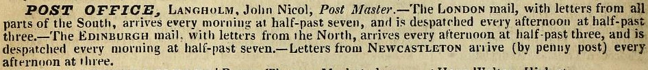 Some info about Dumfries post office: 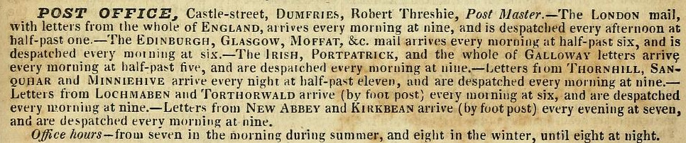 p.s. From the same Pigot I read that M'Gowan William, the addressee, was resident at 10 English street. From this map of 1833 we can see Castle street (post office location) and English street: 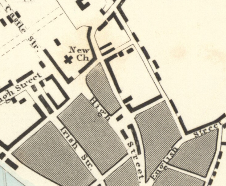 |
|
Send note to Staff
|
| Edited by aryeh - 05/16/2016 04:18 am |
|
|
New Member
Australia
1 Posts |
|
|
The Scottish Postal History is publishing a new book on the Additional Halfpenny Mail Tax 1813-1839 at the beginning of April 2017. The book is almost 400 pages with a huge amount of information and detail including completely new theories on the "Carlisle Red" which, it is almost certain, was applied at Glasgow not Carlisle. There is new information on the Exempt Border towns and other discoveries which show that some of the maps showing accepted mail routes over the years are factually incorrect. Almost every knpown Add Half handstamp has been illustrated on cover. |
|
Send note to Staff
|
|
|
Valued Member
Australia
283 Posts |
|
|
Aryeh,
Many thanks for those cuttings and the other information. Very interesting.
All these bits are grist to our mill<grin>
Michael
Thanks for that information and it sounds as if this is going to be the definitive book. Certainly a massive improvement on the H&S, that that has been a great help to me in sorting our material
Some of the marks can be a bit of a puzzle and it will be great to see the actual marks on piece as opposed to the illustrations. Look forward to any more information.
Any other Addl Half buffs on the forum?
Cheers
Ron |
|
Send note to Staff
|
|
|
Replies: 29 / Views: 5,643 |
|


