| Author |
 Replies: 643 / Views: 152,271 Replies: 643 / Views: 152,271 |
|
|
|
Pillar Of The Community
United States
7239 Posts |
|
|
On October 1, 1974 Japan issued a 2 stamp set to publicize the "61st Inter-Parliamentary Conference" held in Tokyo. The lower value 20 yen stamp (Sc #1181) features a projection map of the world.  |
Send note to Staff 
|
|
|
Pillar Of The Community
7838 Posts |
|
|
Map of Sierra Leone and airplane, engraved and printed by Waterlow & Sons, Ltd., and issued for use in Sierra Leone on January 2, 1956, Scott No. 203. - nethryk  |
|
Send note to Staff
|
|
|
Pillar Of The Community
United States
7239 Posts |
|
|
This 1997 issue of Mauritius depicts Admiral Mahe de La Bourdonnais (1699-1753) and a map with a route from France to India. The map does not include a route to Mahe on the west coast of India. This is the town where Admiral La Bourdonnais had the "Mahe" added to his name by virtue of his conquest of it. Admiral Mahe de La Bourdonnais is shown on this stamp because he was Governor of "Isle de France", the French name for Mauritius at the time, for five years.  |
|
Send note to Staff
|
|
|
Pillar Of The Community
7838 Posts |
|
|
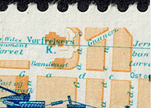
By the Treaty of London of 1839, the southern provinces of the Netherlands, independent de facto since 1830, became internationally recognized as the Kingdom of Belgium, while the province of Limburg was split into Belgian and Dutch parts. Here is an image of a stamp depicting a map showing the division of Limburg, designed by Willy Bosschem (1930- ), printed by lithography, and issued by Belgium on October 2, 1989 to commemorate the 150th anniversary of the treaty, Scott No. 1327. - nethryk  |
|
Send note to Staff
|
|
|
Pillar Of The Community
United States
7239 Posts |
|
|
On August 9, 1974 Singapore issued a set of 3 stamps (S.G. #s 238-40) to publicize the U.N.'s World Population Year. The backgrounds of these stamps are made up of a series of stylized outlines of upper human torsos. The 75c value features a world map defined by the shading of the torsos. From a normal viewing distance, the map is clearly visible. Under magnification, however, the torsos are visible, but the map is not clearly discernible. North and Central America are shown on the close up pic.   |
|
Send note to Staff
|
|
|
Pillar Of The Community
United States
7239 Posts |
|
|
A world map printed in silver ink appears on this 1992 Polish stamp commemorating the World Congress of Poles.  |
|
Send note to Staff
|
|
|
Pillar Of The Community
United States
7239 Posts |
|
|
On June 21, 1991 Poland issued a stamp commemorating the 30th Anniversary of the enactment of the U.N.'s Antarctic Treaty. There are 54 signatory nations of the Treaty. The map shown signifies the territory involved, i.e. 60 degrees latitude south. From Wikipedia, "The treaty sets aside Antarctica as a scientific preserve, establishes freedom of scientific investigation, and bans military activity on the continent."   |
|
Send note to Staff
|
|
|
Bedrock Of The Community
United States
28693 Posts |
|
|
Colombia Agustín Codazzi Geographic Institute April 19, 2016 The stamp depicts production of maps and cartography of Colombia.  |
|
Send note to Staff
|
|
|
Bedrock Of The Community
United States
28693 Posts |
|
|
Australian Antarctic Territory Mapping the AAT August 20, 2019 Set of four, one stamp depicts a map of Antarctica based on a cartographic survey by Douglas Mawson in his 1911-1914 expedition.  |
|
Send note to Staff
|
|
|
Bedrock Of The Community
United States
28693 Posts |
|
|
Austria The Fussach Messenger September 27, 2014 The stamp depicts a 16-century map showing the route for Lindau - Fussach - Milan Courier Service.  |
|
Send note to Staff
|
|
|
Pillar Of The Community
United States
7239 Posts |
|
|
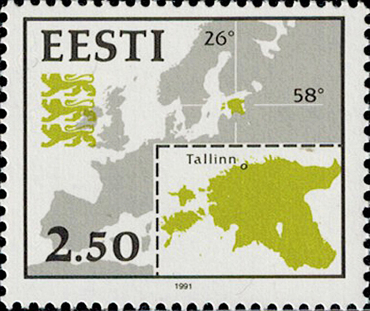
The Via Baltica Highway on a map of the Baltic States is shown on this April 20, 1995 souvenir sheet (Sc. #289) of Estonia.  |
|
Send note to Staff
|
|
|
Pillar Of The Community
United States
7239 Posts |
|
|
This May 6, 2011 souvenir sheet of Estonia anticipates the bicentenary (2016) of the Struve Geodetic Arc. One stamp depicts F. G. W. Struve (1793-1864), and the other stamp shows the Tartu Observatory (1821). The red, vertical line is the meridian, and the ragged white line is the chain of survey triangulations. A posting on page 34 of this thread shows Moldova's issue for the bicentenary of the Struve Geodetic Arc. From Wikipedia, "The Struve Geodetic Arc is a chain of survey triangulations stretching from Hammerfest in Norway to the Black Sea, through ten countries and over 2820 km., which yielded the first accurate measurement of a meridian. The chain was established and used by German-born Russian scientist Friedrich G. W. von Struve in the years 1816 to 1855 to establish the exact size and shape of the earth. At that time, the chain passed merely through two countries: Sweden-Norway and the Russian Empire. The Arc's first point is located in Tartu Observatory in Estonia, where Struve conducted much of his research."   |
|
Send note to Staff
|
| Edited by bookbndrbob - 12/05/2019 12:25 pm |
|
|
Pillar Of The Community
United States
7239 Posts |
|
|
Pillar Of The Community
United States
7239 Posts |
|
|
Bedrock Of The Community
United States
28693 Posts |
|
|
Austria Brexit January 31, 2020 The design shows a map of the European Union without the United Kingdom.  |
|
Send note to Staff
|
| Edited by KuoLC5310 - 02/11/2020 08:51 am |
|
|
Replies: 643 / Views: 152,271 |
|