| Author |
 Replies: 643 / Views: 152,282 Replies: 643 / Views: 152,282 |
|
|
|
Pillar Of The Community
United States
3222 Posts |
|
|
Bedrock Of The Community
United States
28693 Posts |
|
|
Spain 50 Years of ICEX Scholarships April 4, 2025 The stamp shows a stylized world map.  |
Send note to Staff 
|
| Edited by KuoLC5310 - 04/05/2025 08:21 am |
|
|
Bedrock Of The Community
United States
28693 Posts |
|
|
Estonia Topographical Estonia May 6, 2025 The stamp shows a physical map of Estonia.  |
|
Send note to Staff
|
|
|
Bedrock Of The Community
United States
28693 Posts |
|
|
Tristan da Cunha 70th Anniversary of the Gough Island Scientific Survey November 13, 2025 Set of six, one stamp shows a physical map of the island. 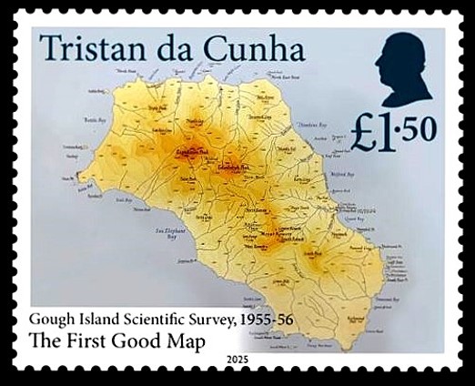 |
|
Send note to Staff
|
|
|
Valued Member
Philippines
317 Posts |
|
|
This stamp was issued to commemorate the first anniversary of the ending of a border dispute between Paraguay and Bolivia. The 500 pesos airmail stamp was issued in 1939. The inscription roughly translate "An honorable peace is worth more than all military triumphs". (World leaders please take note). The stamp was postmarked at the capital of Asuncion on June 11 or 17. 1942. The map shows the Chaco region that was in dispute. 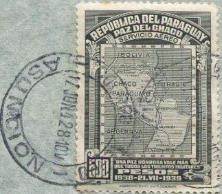 |
|
Send note to Staff
|
|
|
Valued Member
Philippines
317 Posts |
|
|
Anguilla wasn't always independent. It was part of St. Kitts Nevis & Anguilla but there was some intense dissatisfaction concerning fiscal matters and their representation in the world by those mostly on St. Kitts who spoke for them beyond their island. In 1967 the locals declared their independence and in the process created their first set of postage stamps. They overprinted existing stocks on hand of the then current St. Kitts Nevis & Anguilla stamps. The stamps were very popular and stocks on hand were very low. Some values sold out quickly making complete sets a challenge. The design is a map of Anguilla and the postmark is of a place found in the middle of the island: VALLEY (November 25, 1967) . The location of Valley is depicted on the map. The denomination is $2.50 which would have served as a stamp for parcels, I surmise. 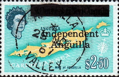 |
|
Send note to Staff
|
|
|
Valued Member
Philippines
317 Posts |
|
|
Seychelles reprised this design in 1954 with the change of the monarch. It is not so much a map of Seychelles but rather a wall map showing where the islands are located relative to Africa, Arabia and India. This particular 18 cent stamp was posted in 1954 from the capital, VICTORIA. 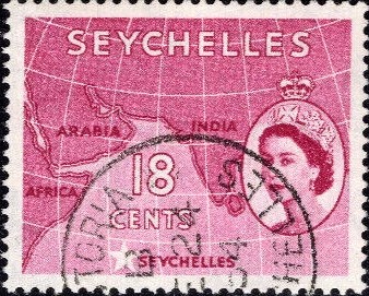 |
|
Send note to Staff
|
|
|
Valued Member
Philippines
317 Posts |
|
|
In 1954, Nauru issued this five shilling stamp showing a map of their island. It was also known as Pleasant Island. The engraved stamps showed all the districts that comprised the political jurisdictions on the island. Nauru is located in the Central Pacific as the postmark would tell us if only the cancel was socked on the nose. 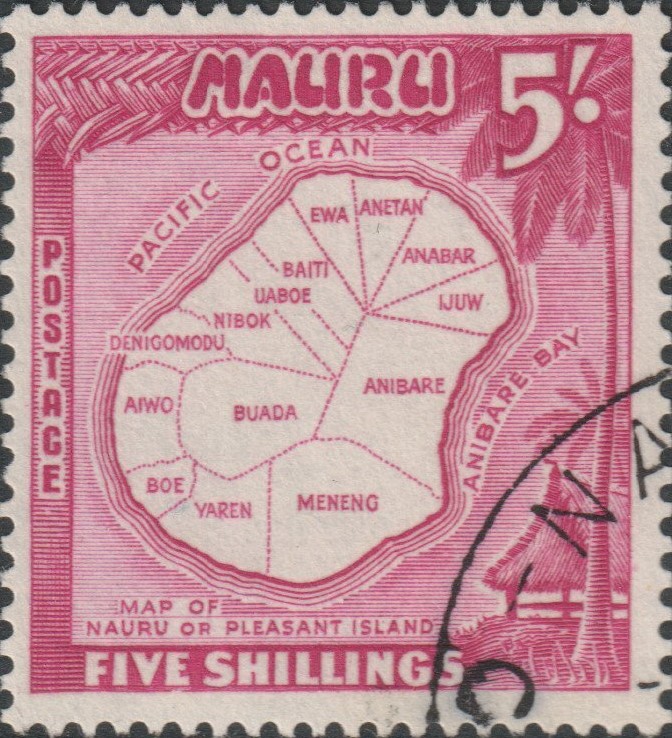 |
|
Send note to Staff
|
|
|
Valued Member
Philippines
317 Posts |
|
|
This half-penny Ghana postage stamp was issued in March 1957. It commemorates the Independence of the African country by means of an overprint. It was postmarked in ACCRA twelve days after the nation became independent. The design shows a map of West Africa and highlights where Gold Coast was located. Gold Coast was renamed Ghana upon becoming independent. 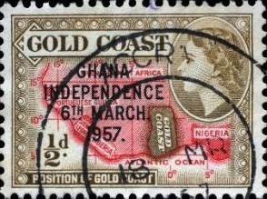 |
|
Send note to Staff
|
|
|
Valued Member
Philippines
317 Posts |
|
|
In 1938, British Guiana issued this four cent stamp which answered the question "where in the world was this country located?" The engraved postage stamp appears to have been used at a SAVINGS BANK N.A . if I am reading the postmark correctly. 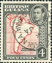 |
|
Send note to Staff
|
|
|
Bedrock Of The Community
United States
28693 Posts |
|
|
Croatia Week Of Croats Abroad May 26, 2026 The stamp shows the distribution of Croats on a stylized world map. 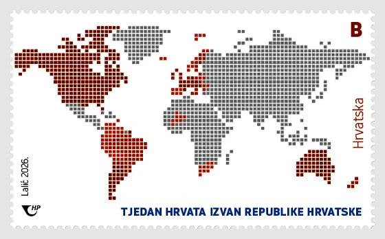 |
|
Send note to Staff
|
|
|
SCF Advertiser
73 Posts |
|
|
Valued Member
Philippines
317 Posts |
|
|
SALITRE-CUE
11.NOV.1933
- PARAGUAY -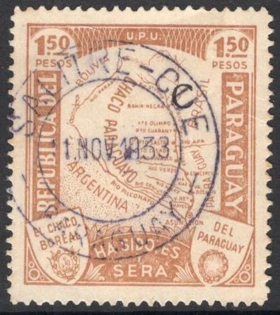 SG 433 Salitre Cué is a historical and natural tourist destination in Paraguay, located in the José Leandro Oviedo district in the Itapúa Department, approximately 100 km north of Encarnación. During the War of the Triple Alliance, the area served as a crucial supply hub where the army processed salitre (saltpeter) to make gunpowder. |
|
Send note to Staff
|
|
|
Replies: 643 / Views: 152,282 |
|