| Author |
 Replies: 11 / Views: 4,281 Replies: 11 / Views: 4,281 |
|
|
Bedrock Of The Community
United States
12128 Posts |
|
|
I found this Registered Mail Card for sale on ebay and it intrigued me because I had never heard of a "Darby, Massachusetts". The card refers to it as being in "Plymouth County" and indeed Jim Forte's Postal History Website confirms that it was a short-lived post office only in operation for three short years (1905-1907). As a result there doesn't seem to be many historical maps or references showing where this post office would have actually been located. 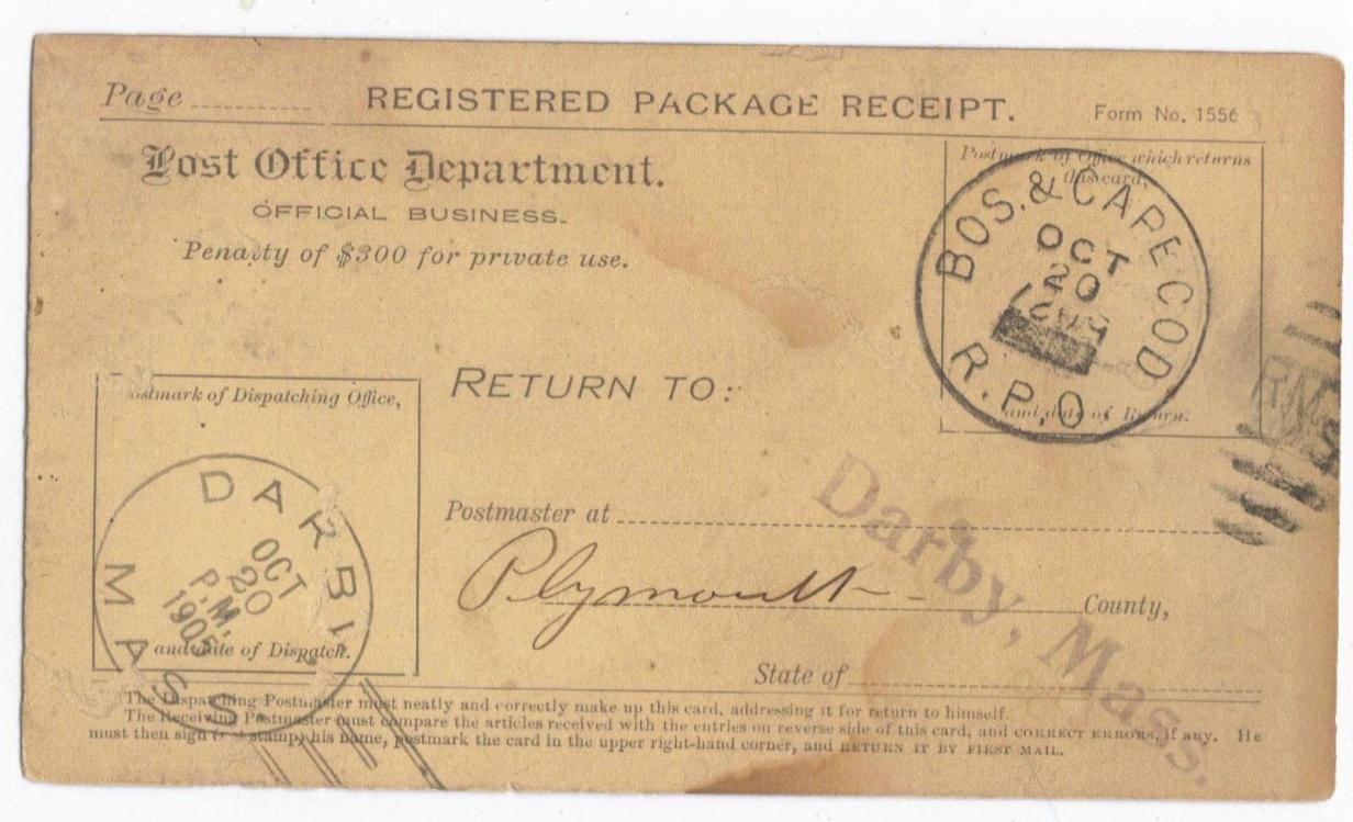 Any ideas? |
|
Send note to Staff
|
|
|
|
|
Pillar Of The Community
6343 Posts |
|
|
Darby is the first town inland from Plymouth. 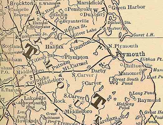 Scan from the Massachusetts map in the "The Twentieth Century Peerless Atlas, Pictorial Gazetteer of all Lands" published by The Crowell Publishing Co of New York, NY, 1908. The book's cover titles it as the "Peerless Atlas of the World" |
Send note to Staff 
|
|
|
Pillar Of The Community
6343 Posts |
|
|
The USPS has also microfilmed (and now maybe digitized?) their site location reports, filed for establishing and moving offices. Filmed county-by-county for each state. Seems like they cover about 1840-1930. I don't have the exact reference to them handy, but they should be easy to locate as a government publication. Each site report asks the postmaster to draw a map locating his office, roads, nearby towns, etc., so very handy to study the maps on reports from the nearby offices and combine the features. |
|
Send note to Staff
|
|
|
Pillar Of The Community
United States
2758 Posts |
|
|
Bedrock Of The Community
United States
12128 Posts |
|
|
Thanks. Where did you get that Peerless Atlas page from? Is it online or do you actually have a copy of the Atlas? I've been trying to research the post office name using historical and USGS maps that are searchable online but they all seemed to either pre-date or post-date the time in which that post office was around which meant the name was either dropped or changed. |
|
Send note to Staff
|
|
|
Bedrock Of The Community
United States
12128 Posts |
|
|
Pillar Of The Community

United States
1951 Posts |
|
|
Family,
Darby, Mass was a station stop on the Old Colony Line from Plymouth to Middleborough, Mass. It was known for its "cranberry trains". The Old Colony RR was later absorbed into the New York, New Haven, and Hartford RR.
This would also explain the "RPO" cancellation on the Registered Package Receipt.
Jack Kelley |
|
Send note to Staff
|
|
|
Pillar Of The Community
6343 Posts |
|
|
I own the Peerless atlas.
While the Davidrumsey.com site has an incredible collection of maps, there is nothing like having maps and other reference materials on hand. |
|
Send note to Staff
|
|
|
Bedrock Of The Community
United States
12128 Posts |
|
|
Thanks. That explains it. I must have spent an hour or more looking at online maps of the Plymouth and Plymouth County area without luck in finding "Darby". I did subsequently find this link, though, that explains it pretty well (if you search for "Darby" among all the other stops on the old Middleborough and Plymouth Railroad line). Although the images are rather poor, the story is quite interesting: http://nemasket.blogspot.com/2009/0...ailroad.html |
|
Send note to Staff
|
| Edited by wt1 - 03/16/2015 5:14 pm |
|
|
Pillar Of The Community
United States
854 Posts |
|
|
Use of a Doane handstamp is consistent with a newly opened post office in this time period. This example is, incidentally, earlier than the previous EKU for Darby by a couple of months (per the doanecancel.com listings). Nice item. |
|
Send note to Staff
|
|
|
Pillar Of The Community
6343 Posts |
|
|
Here is a different map with Darby on it. I have always liked the small town detail in this atlas. 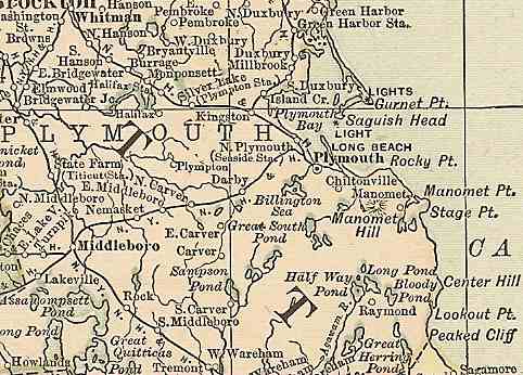 Scanned from the Massachusetts, Connecticut and Rhode Island plate of an atlas with the title page missing, but with a front cover titled "1920 New World Atlas". Internal plates are copyrighted by C S Hammond & CO of New York, NY. |
|
Send note to Staff
|
|
|
Bedrock Of The Community
United States
12128 Posts |
|
|
Thanks for the additional map. Although this has nothing to do with Darby or its former post office, just southeast of that location is a body of water referred to as "Billington Sea" (a Sea?!?) -- which has a rather humorous story behind it: 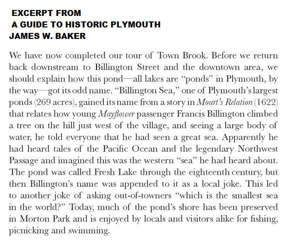 |
|
Send note to Staff
|
| Edited by wt1 - 03/16/2015 9:52 pm |
|
| |
Replies: 11 / Views: 4,281 |
|


