| Author |
 Replies: 52 / Views: 9,799 Replies: 52 / Views: 9,799 |
|
|
|
Valued Member
United States
262 Posts |
|
|
SWH
I realized that I forgot to answer your second question. Went back and looked at some of the history, and indeed Upper Volta had some changes in 1933 but I don't fully understand, nor have I captured it in my chart. Let me do a little research and I will get back to you, and will also need to update my chart.
Thank you for catching my error.
Michael |
Send note to Staff 
|
|
|
Valued Member
United States
262 Posts |
|
|
Hi SWH
I have updated my chart at DCStamps, to indicate the following changes
The Colony of Upper Volta (Haute Volta) was partitioned across French Sudan, Niger and Côte d'Ivoire on 1 Jan, 1933. This was done for financial reasons. After WW2, the Territory of Upper Volta was formed on Jan 4, 1947. This territory used stamps of FWA and never issued stamps of its own.
Thanks again for helping me clarify and correct Upper Volta on my Transition Chart.
Michael |
|
Send note to Staff
|
|
|
Rest in Peace
Netherlands
153 Posts |
|
|
Hi Micheal
That's fast! Coming back Upper Senegal and Middle Niger: when you Google exactly that you will see a link to a book called Historical Dictionary of Mali. On the page Google leads you to you will see exactly what I mean. (I would have posted the link but I don't think I am allowed to do so as e newbie on the forum) |
|
Send note to Staff
|
|
|
Pillar Of The Community
United Kingdom
3214 Posts |
|
|
Hi Michael,
I enjoy looking at your diagrams very much.
I suggest your box "British Ghana" should be "Gold Coast, British Colony" to keep it in the same style as the rest of the diagram. |
|
Send note to Staff
|
Nigel |
|
|
Valued Member
United States
262 Posts |
|
|
SWH
Just so you know, I am looking at various sources, and unfortunately they are not necessarily consistent. However, from what I can work out, in 1899, as they broke up French Sudan, the French also created two additional colonies: Upper Senegal and another called Middle Niger. In 1902, these two colonies rejoined to become Senegambia and Niger. Upper Senegal and Middle Niger never issued stamps of their own, and as far as I understand they continued to use French Sudan stamps until 1903, when a set o stamps inscribed Senegambia and Niger were issued. Will validate and fix.
Nigel
You are of course correct. I wasn't paying much attention to the non-French part. Will fix this also.
Thanks again to you both.
|
|
Send note to Staff
|
|
|
Rest in Peace
Netherlands
153 Posts |
|
|
Micheal I have come about some inconsistency too: sources either speak of one or of two colonies or territories. I have come across multiple sources though that state that they were administered by one and the same person, called Merlaud-Ponty with the title of delegate. Actually he was in charge from 1899 until 1904 so including the period of Senegambia & Niger. Please check this resource https://books.google.nl/books?id=zf...1899&f=false |
|
Send note to Staff
|
|
|
Valued Member
United States
262 Posts |
|
|
SWH
Thanks, I did already see this reference (among others). But you helped point me in searching for William Merlaud-Ponty, an interesting guy and important anti-slavery figure. Nowhere am I completely satisfied with a full explanation but found an interesting explanation of what was happening in the region during this time in a book called: Slavery and Colonial Rule in French West Africa by Martin A. Klein. Here is a brief explanation from his book:
"In October, 1899, a new Minister of Colonies, Albert Decrais, reorganized the Sudan. The southern cercles were attached to coastal colonies. Two territories were left under military rule, one centered in Ouagadougou and the second at Timbuktu. In 1900, a new military territory was set up in what is now Niger. The largest part of Sudan was renamed Haut Senegal et Moyen Niger and placed under the control of the Governor-General with a representative in Kayes called the Delegue General. The first and only Delegue General was William Merlaud-Ponty, one of the few civilian administrators in the Sudan.
In 1904, Haut-Senegal-Niger became a full colony once again and Ponty became a Lt. Governor."
This helps a lot to understand what was going on at the time. Although it doesn't mention the name change to Senegambia and Niger in 1902 (that I read in many other places), it does tell us that it was a territory in flux.
Thanks for making me do the research and pointing me towards William Merlaud-Ponty. I think with this. I will create box called "Upper Senegal and Middle Niger territory from 1900-1902 and place it between French Sudan and Senegambia and Niger. And leave it at that.
When I complete the changes, I will let you know when it is up.
Michael |
|
Send note to Staff
|
|
|
Valued Member
United States
262 Posts |
|
|
Rest in Peace
Netherlands
153 Posts |
|
|
Looks good! Nice reference, thanks for sharing. I had come across the formation of those districts but it is always good to have confirmation again and again. On maps - I'll be posting these on my site sometime in the future - the situation would to my understanding look like this: 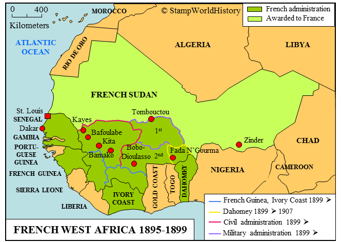 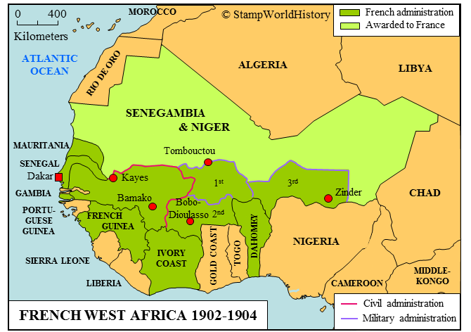 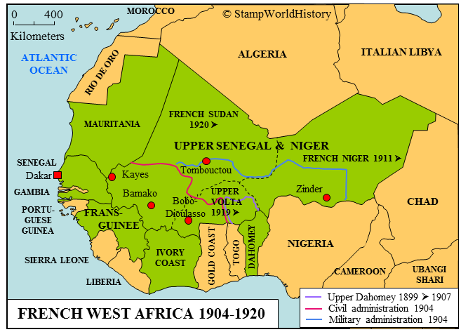 Any feedback is welcome. Gerben |
|
Send note to Staff
|
|
|
Pillar Of The Community
1448 Posts |
|
|
Nice Maps.  Gerben- Have you found any period maps of the era that are labeled "Senegambia & Niger"? I've been unsuccessful. BTW, if one is interested in WW classical and modern era stamp collecting, and the accompanying history of the formation of countries, check out Gerben's website. http://www.stampworldhistory.com/His synthesis maps are amazing.  |
|
Send note to Staff
|
|
|
|
Pillar Of The Community
1448 Posts |
|
|
Quote:
Ok, changes made and the Transition Chart it is available at DCStamps. Michael- superb as usual. Did you think it would be this much work when you took this on as a request favor?  |
|
Send note to Staff
|
|
|
|
Valued Member
United States
262 Posts |
|
|
SWE
Nice Maps. Where did you get them, or did you do them yourself.
There is a real problem with the transition between the first and the second map, as in 1899, the majority of French Sudan was divided across the colonies which were closer to shore. I will check some sources to see if there is any maps which depict the division.
Michael
|
|
Send note to Staff
|
|
|
Valued Member
United States
262 Posts |
|
|
Rest in Peace
Netherlands
153 Posts |
|
|
Jkjblue When I made the maps a few years ago I had a period map for Senegambia & Niger of which I now only have the small part I actually used. Which is the part showing how Senegal is reduced to a strip of land along the coast and the Senegal River from 1902 until 1904. I looked around but was not able to find that particular map again. I did find this map though: http://www.carto-mondo.fr/carte/car...ancais-1900. The site dates it 1900 but it clearly reads Senegambie et Niger so the site may just be wrong - Senegambie being formed in 1902. (I think it is the same map Micheal is referring to but his link doesn't work) Hope this helps. |
|
Send note to Staff
|
|
|
Rest in Peace
Netherlands
153 Posts |
|
|
Micheal Thanks for looking into this again - there must come a point when you have had enough of French West Africa and all its complexity. Thanks for the link too - small problem: the first two don't seem to work? I made the maps using resources that described the changes in 1899, 1902 and 1904 in great detail including what provinces - to the extent that they had been defined at the time - were transferred from one country to another and what provinces were to become part of the military and civil territories. All this based on the original decrees from the French government. I combined this info with a 1912 map showing the provinces in French West Africa. Thus I think I came up with a close enough approximation of the territorial changes of the time. Here's a link to the map I used - on a rather interesting site when you like maps: http://gallica.bnf.fr/ark:/12148/bt...596b/f1.zoom |
|
Send note to Staff
|
|
|
Replies: 52 / Views: 9,799 |
|


