| Author |
 Replies: 341 / Views: 110,733 Replies: 341 / Views: 110,733 |
|
|
|
Bedrock Of The Community
United States
28583 Posts |
|
|
United States 2026 Colorado Statehood Jagged Mountain (elevation 4215 m) is a peak in the Needle Mountains, a subrange of San Juan Mountains of the Rocky Mountains of North America. The Needle Mountains are primarily composed of 1.5-billion-year-old Precambrian pink granite and older metamorphic basement rocks, forming jagged peaks that stand out from the younger volcanic rocks of the surrounding San Juan Mountains. 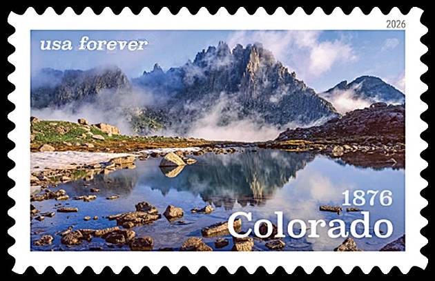 |
Send note to Staff 
|
|
|
Bedrock Of The Community
United States
28583 Posts |
|
|
France 2025 80 years of UNESCO - 10 World Heritage Sites in Occitanie Mont Perdu (elevation 3355 m) is a massive limestone peak within the axial zone of the Pyrenees, a 430 km long mountain range created by tectonic collision of the Iberian and European plates. The area features classic Pyrenean landforms including deep canyons and dramatic cirques. The main phase of orogeny and deformation occurred during early Tertiary period. 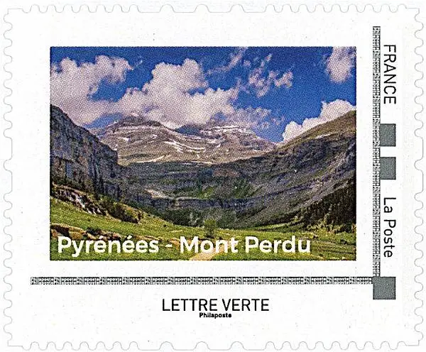 |
|
Send note to Staff
|
|
|
Bedrock Of The Community
United States
28583 Posts |
|
|
Switzerland 2023 Swiss River Landscapes Breggia Gorge is located in the lower Muggio Valley in the Canton of Ticino. The site features nearly continuous layers of ancient Tethys Ocean sediments from the Jurassic to the Tertiary periods. These rock formations are geologically African/Adriatic in origin, now incorporated into the collision zone on the southern edge of the Eurasian plate. 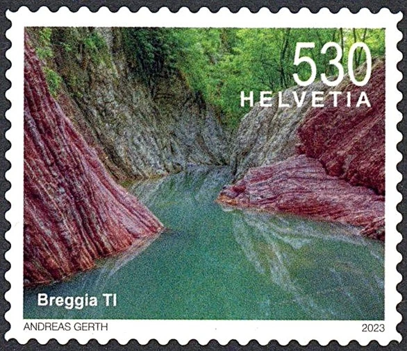 |
|
Send note to Staff
|
|
|
Bedrock Of The Community
United States
28583 Posts |
|
|
Iraq 2025 Landmarks Gara Mountain is located in the Kurdish Mountains on the border between northern Iraq and Turkey. It is part of the Zagros Mountain belt, where the Tethys Ocean was closed, and its sediments squeezed upward, by the collision of the Arabian and Eurasian tectonic plates about 30 million years ago. 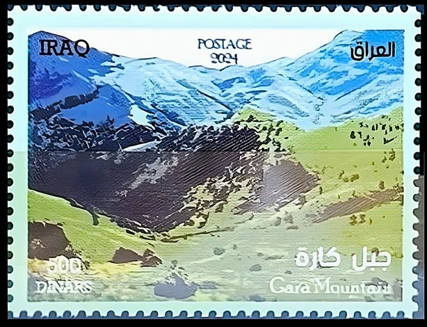 |
|
Send note to Staff
|
|
|
Bedrock Of The Community
United States
28583 Posts |
|
|
Israel 2023 Springs in Israel Ein Akev, located in the Zin Valley of Negev Desert of southern Israel, features a small box canyon carved into Eocene-aged limestone, cherty chalk, and marl formations, with springs emerging from a waterfall. The Zin Valley was shaped by Tethys Ocean sediments followed by tectonic forces related to the Dead Sea Rift, the northernmost segment of the massive, 5000-km-long Syrian-African Rift Valley. 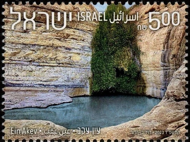 |
|
Send note to Staff
|
|
|
Bedrock Of The Community
United States
28583 Posts |
|
|
United Arab Emirates 2025 Liwa Oasis Liwa Desert in Abu Dhabi is dominated by massive megabarchan dunes, which are complex, compound structures often over 150 meters in height. The sand is primarily iron-oxide coated quartz, which gives it a reddish-orange color. Major dune building took place during dry periods in the last 100000 years.  |
|
Send note to Staff
|
|
|
Bedrock Of The Community
United States
28583 Posts |
|
|
Iran 2020 Landscapes Maranjab Desert forms part of Great Salt Basin lying in the middle of the Iranian Plateau. The area features golden sand dunes (Band-e-Rig) up to 100 meters high, salt pan plains, and seasonal wetlands. Arid climate formed during the Quaternary period, with landscapes shaped by ongoing aeolian processes. 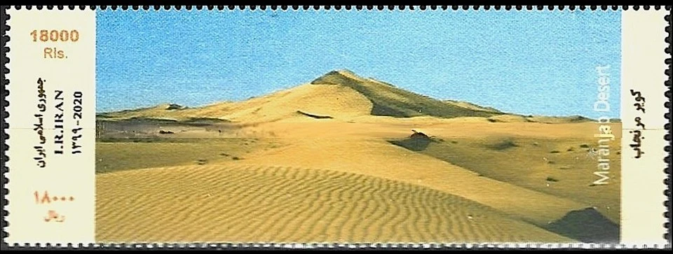 |
|
Send note to Staff
|
|
|
Bedrock Of The Community
United States
28583 Posts |
|
|
Turkey 1997 World Environment Day - Erosion Nallihan Mountains, known as the "Rainbow Hills" in Ankara, are a Neogene (10 to 20 million years ago) geological formation shaped by erosion. Natural erosion on sedimentary rocks exposed layers of red (iron), yellow (humus), and green (clay) hues, creating striped, colorful outcrops. 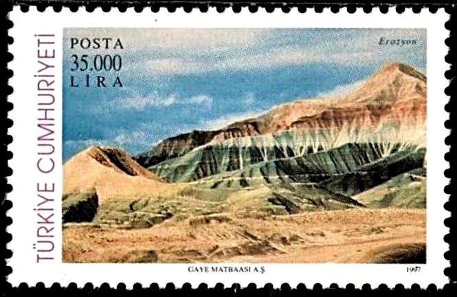 |
|
Send note to Staff
|
| Edited by KuoLC5310 - 03/28/2026 7:31 pm |
|
|
Bedrock Of The Community
United States
28583 Posts |
|
|
Armenia 2025 Sights of Armenia Mount Azhdahak (elevation 3597 m) is the highest point of Gegham mountains, a 70 km long, 40 km wide range of volcanic origin. The extinct volcano comprises Pliocene to Quaternary-aged (2.5 million years to recent) scoria, basaltic lavas, volcanic ash, and obsidian. Magmatism in this region is associated with collision of the Arabian and Eurasian plates. 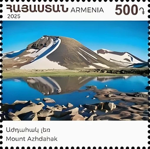 |
|
Send note to Staff
|
|
|
Bedrock Of The Community
United States
28583 Posts |
|
|
Romania 1987 Landscapes Ceahlau Massif is part of the Bistrita Mountains of the Eastern Carpathians. It is a synclinal mountain composed of Lower Cretaceous conglomerate and sandstone formations, while many of its peaks (such as Toaca shown on the stamp) are limestone klippes, erosional remnant of a thrust sheet emplaced by convergent tectonic force. 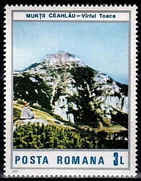 |
|
Send note to Staff
|
| Edited by KuoLC5310 - 04/20/2026 09:09 am |
|
|
Bedrock Of The Community
United States
28583 Posts |
|
|
Italy 2025 Tourism - Latemar Group Trentino-Alto Adige is a region in northern Italy bordering Switzerland and Austria. The region encompasses part of the Dolomites, a section of the Italian Alps known for sawtooth limestone peaks. The rock formation was formed over 250 million years ago in a shallow, tropical sea. 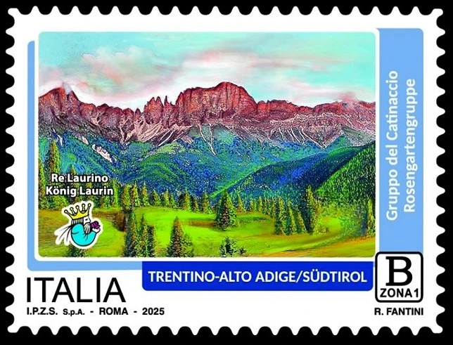 |
|
Send note to Staff
|
|
|
Replies: 341 / Views: 110,733 |
|


