| Author |
 Replies: 643 / Views: 152,230 Replies: 643 / Views: 152,230 |
|
|
|
Pillar Of The Community
7838 Posts |
|
|
Here is an image of a stamp featuring a political map showing the provinces of Uruguay and the nation's coat of arms, printed by lithogravure, and issued by Uruguay on September 21, 1984, Scott No. 1167. - nethryk  |
Send note to Staff 
|
| Edited by nethryk - 08/25/2012 6:53 pm |
|
|
Pillar Of The Community
USA
9748 Posts |
|
|
Kirk, I would like a map of Brooklyn with the neighborhoods defined..i was just a little kid but I remember visiting relatives here and there..but kids didn't have a need to know whether it was Bushwick or Williamsburg or Ridgewood or Bedford Stuyvesant ..wherever , kids were allowed to roam free and stay out of the adults way !! I can't believe the difference nowadays when I see parents taxi ing kids to sports practice and such...that was not going to happen in those "happy days" |
|
Send note to Staff
|
APS 070059 Life Member International Society of Guatemala Collectors I.S.G.C. #853 |
|
|
Pillar Of The Community
USA
9748 Posts |
|
|
Ok, enough social comment on how I became a menace to society, heres a couple of the many maps from down Argentine way !! 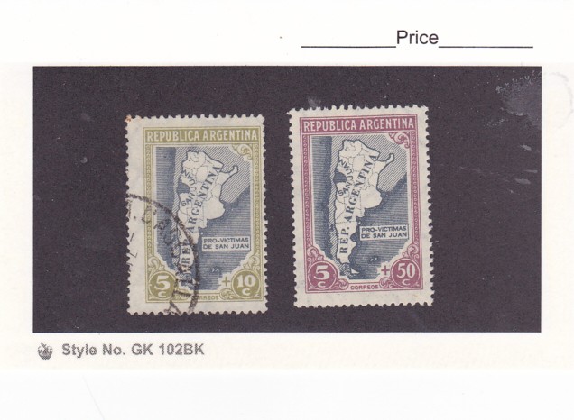 |
|
Send note to Staff
|
APS 070059 Life Member International Society of Guatemala Collectors I.S.G.C. #853 |
|
|
Pillar Of The Community
United States
898 Posts |
|
|
Nethryk: I really like the quality of your scans, especially the Nicaragua map on the prior page. May I ask what kind of settings (esp dpi) you're scanning these at? Any special software? Or using a top-of-the-line scanner?
Thanks in advance,
-- Dave |
|
Send note to Staff
|
|
|
Pillar Of The Community
7838 Posts |
|
|
Philatarium - Thanks! For all of my stamp images I use an Epson Perfection V300 Photo scanner, operating in professional mode. For images of single stamps, I generally scan at a resolution setting of 1200 dpi, in 48 colors; for multiples and souvenir sheets, I usually scan at 600 dpi. I edit all of my images in Picasa 3 before uploading them to photobucket. In photobucket, I resize the images of engraved stamps to 800x600, and for other, less-detailed images (e.g., of stamps printed by lithogravure or photogravure), I generally resize to 640x480 before posting. - nethryk |
|
Send note to Staff
|
|
|
Pillar Of The Community
7838 Posts |
|
|
Map of Tongatapu, designed by British commercial artist and designer James Berry (1906-1979), engraved and printed by Bradbury, Wilkinson & Co., and issued for use in Tonga on July 1, 1953, Scott No. 104, SG No. 105. - nethryk  |
|
Send note to Staff
|
|
|
Pillar Of The Community
USA
9748 Posts |
|
|
Nice !! |
|
Send note to Staff
|
APS 070059 Life Member International Society of Guatemala Collectors I.S.G.C. #853 |
|
|
Pillar Of The Community
United States
898 Posts |
|
|
Nethryk: Thanks very much for sharing your scanning tips. You do just a great job! I have an HP scanner, and need to see what I can get it to do. I typically haven't used such a high resolution, but it looks like it does make a difference. To edit and resize an image, I've used either Photoshop Elements or Irfanview, but might try to Picasa 3 as well. Are there typical adjustments (like for sharpening, etc.) that you do in Picasa?
Thanks again,
-- Dave |
|
Send note to Staff
|
|
|
Pillar Of The Community
7838 Posts |
|
|
philb - Thanks! Glad you liked that one.
Philatarium - You're welcome. The most essential thing is to use a photo scanner, not a document scanner. In Picasa 3, the only image adjustments that I routinely use are: Straightening, Cropping, and Shadows (to counter the "bleaching" effect of the harsh photocopier light).
- nethryk |
|
Send note to Staff
|
|
|
Pillar Of The Community
7838 Posts |
|
|
Map of the V.I. Lenin Volga-Baltic Waterway (completed in 1964), designed by Lesegri (the collective name of three Soviet artists and designers of postage stamps: Boris Lebedev, Leonard Sergeyev and Mark Greenberg), printed by lithogravure, and issued by Russia (USSR) on April 6, 1966, Scott No. 3180, Zagorski No. 3303. - nethryk  |
|
Send note to Staff
|
|
|
Pillar Of The Community
7838 Posts |
|
|
Map showing Saint Paul's route from Caesarea to Rome, designed by Piero Grassellini, printed by photogravure, and issued by Vatican City on June 13, 1961 as one of six stamps commemorating the 19th centenary of Saint Paul's arrival in Rome, Scott No. 304. - nethryk  |
|
Send note to Staff
|
| Edited by nethryk - 09/19/2012 08:52 am |
|
|
Valued Member
United Kingdom
172 Posts |
|
|
I know the 24p has already been shown, thought I'd add the rest of the issue. Great Britain, 1991, Bicentenary of Ordinance Survey: Maps of Hamstreet, Kent (24p - Map of 1816, 28p - Map of 1906, 33p - Map of 1959 and 39p - Map of 1991) 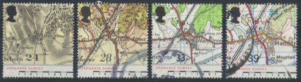 |
|
Send note to Staff
|
|
|
Pillar Of The Community
7838 Posts |
|
|
Here is an image of an airmail stamp depicting a map of South America, highlighting Brazil, Bolivia, and the route of a visit to Brazil by Bolivian President Enrique Peñaranda del Castillo (1892-1969), printed by lithogravure, and issued by Brazil on June 30, 1943, Scott No. C49. Historical note: President Peñaranda was overthrown in a military coup six months later. - nethryk  |
|
Send note to Staff
|
| Edited by nethryk - 09/30/2012 09:55 am |
|
|
Pillar Of The Community
7838 Posts |
|
|
Here is an image of a stamp depicting Viking routes, designed and engraved by Max Müller, and issued by Faroe Islands on March 15, 1982, Scott No. 81, Facit No. 72. - nethryk  |
|
Send note to Staff
|
|
|
Valued Member
Netherlands
207 Posts |
|
|
Replies: 643 / Views: 152,230 |
|