| Author |
 Replies: 643 / Views: 152,237 Replies: 643 / Views: 152,237 |
|
|
|
Rest in Peace
United States
4052 Posts |
|
|
Pillar Of The Community
Slovenia
838 Posts |
|
|
London Undergoud Map
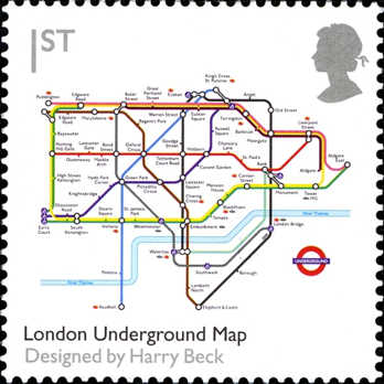
The London Undergoud Map was created by Henry Beck (1902-1974), an English technical draftsman in 1933. |
Send note to Staff 
|
|
|
Pillar Of The Community
7838 Posts |
|
|
Here is an image of an engraved stamp depicting a map of Shanghai indicating the locations of foreign concessions, and issued by the Chinese puppet government in Nanking (under Japanese occupation) on August 1, 1944 to commemorate the first anniversary of the return of the foreign concessions in Shanghai, Scott No. 9N105. - nethryk  |
|
Send note to Staff
|
|
|
Pillar Of The Community
Slovenia
838 Posts |
|
|
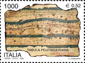
Tabula Peuntingeriana - Codex Vindobonensis 324
.................................Rome
........................................Norico and Panonia provinces
The Tabula Peutingeriana is a road map showing the road network in the Roman Empire. The original map was made in around 5th century.
The unique copy of map was made by a monk in Colmar in the 13th century. It covers Europe, North Africa and parts of Asia (the Middle East, Persia, India). |
|
Send note to Staff
|
|
|
Pillar Of The Community
7838 Posts |
|
|
Map of Grand Comoro, airmail stamp designed and engraved by Pierre Béquet, and issued for use in Comoro Islands on June 28, 1973, Scott No. C53. Note: Mount Karthala is an active volcano and the highest point of the Comoros at 2,361 m (7,746 ft) above sea level. - nethryk  |
|
Send note to Staff
|
|
|
Pillar Of The Community
Slovenia
838 Posts |
|
|
30 Years of the Underground in Tashkent, Uzbekistan - 2007
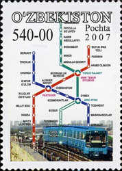
......map of Tashkent Metro
The Tashkent Metro was opened in 1977 when Uzbekistan was part of Soviet Union.
It was the seventh metro built in the former Soviet Union.
Metro has three lines with lenght of 36.2 kilometres and 29 stations.
In 2013 the metro carried 59.2 million passengers.see also my post of London Underground Map: https://goscf.com/t/947&whichpage=24#321030 |
|
Send note to Staff
|
| Edited by primoz - 06/19/2014 05:59 am |
|
|
Pillar Of The Community
Slovenia
838 Posts |
|
|
Pillar Of The Community
7838 Posts |
|
|
Today in history, 1960: The Malagasy Republic attained full independence from France. Here is an image of an engraved stamp depicting singers and a map of Madagascar, issued by Malagasy (Madagascar) on October 14, 1966 in honor of the National Anthem, Ry Tanindrazanay malala ô! ("Oh, Beloved Land of our Ancestors!"), Scott No. 392, plus a YouTube link to a choral rendition of the anthem: https://www.youtube.com/watch?v=3R6nKsSoMuQ- nethryk  |
|
Send note to Staff
|
|
|
Pillar Of The Community
Canada
2574 Posts |
|
|
Peru 1958 Peruvian exhibition in Paris 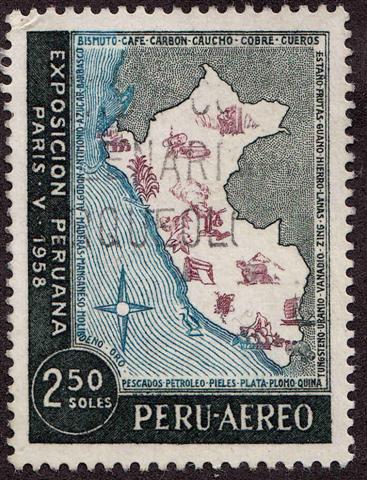 Map of Peru showing national products |
|
Send note to Staff
|
| Edited by timbres667 - 07/03/2014 3:49 pm |
|
|
Moderator

United States
4788 Posts |
|
|
I got a little behind on this thread, but it's one of my favorites.
All good contributions -- some especially nice ones from nethryk.
Thanks,
Kirk |
|
Send note to Staff
|
|
|
Valued Member
United States
42 Posts |
|
|
Translation of text below map: Your heart is your health. Worldwide Heart Month April 1972  |
|
Send note to Staff
|
|
|
Pillar Of The Community
Slovenia
838 Posts |
|
|
Duikers and population maps
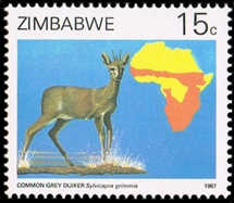 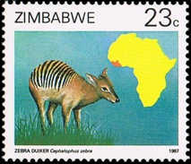 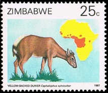
..............common grey duiker...............................zebra duiker............................yellow-backed duiker
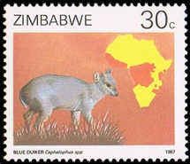 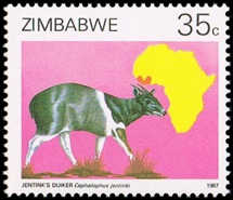 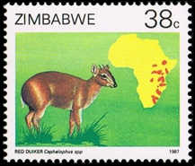
..................blue duiker....................................jentink`s duiker................................red duiker
Duiker is a small African antelope that typically has a tuft of hair between the horns, found mainly in the rain forest.
Stamps show the distribution of certain types of duikers in Africa. |
|
Send note to Staff
|
|
|
Pillar Of The Community
Slovenia
838 Posts |
|
|
Pan-African Tsetse Eradication Campaign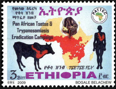 Human African trypanosomiasis Human African trypanosomiasis, also known as sleeping sickness, is a disease spread by an infected tsetse fly. In Africa around 30000 people in 36 countries suffer from this disease. Map shows the widespread presence of Tsetse fly. |
|
Send note to Staff
|
|
|
Pillar Of The Community
Slovenia
838 Posts |
|
|
Martino Martini (1614-1661)
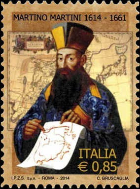
Father Martino Martini is author of the first modern atlas of China,
Novus Atlas Sinesis, published in 1655 in Amsterdam.
In the background of stamp is the map. |
|
Send note to Staff
|
|
|
Pillar Of The Community
7838 Posts |
|
|
KirkS - Thanks! Here is an image of an airmail stamp depicting an airplane flying over a map of North Africa, designed by A. Boutet, engraved by Charles-Paul Dufresne, and issued in 1948 for use in Fezzan (a French-occupied part of Libya), Scott No. 2NC2. - nethryk  |
|
Send note to Staff
|
|
|
Replies: 643 / Views: 152,237 |
|