| Author |
 Replies: 643 / Views: 152,236 Replies: 643 / Views: 152,236 |
|
|
|
Pillar Of The Community
7838 Posts |
|
|
Map of Soviet Union air routes and transport airplanes, airmail stamp designed by Russian artist Ivan Ivanovich Dubasov, printed by photogravure, and issued by Russia (USSR) on November 9, 1949, Scott No. C88, Zagorski No. 1369. - nethryk  |
Send note to Staff 
|
|
|
Pillar Of The Community
Slovenia
838 Posts |
|
|
Vienna the capital of the Republic of Austria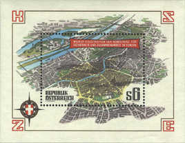 The map shows plan of Vienna from the Southeast. At the upper left corner is Danube River, the Donau Canal cuts through the middle of the stamp. The five-sided street at the bottom of the stamp is the Ring Road the wide avenue which encircles the old city. |
|
Send note to Staff
|
|
|
Pillar Of The Community
Slovenia
838 Posts |
|
|
Vasco da Gama (1460/1469-1524)
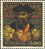 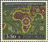 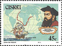 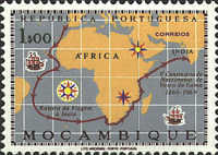
...........................................portrait of Vasco da Gama , maps with the routes of his travel
A Portuguese explorer Vasco da Gama was the first European to reach India by sea. He traveld to India three times.
In 1497 Vasco da Gama led a fleet of four ships traveled around Africa and arrived in India in 1498.
On second travel in 1502 he lead a expedition with 20 war ships.
On his last travel in 1524, with a fleet of fourteen ships, he traveled along with two of his sons. Da Gama contracted malaria not long after arriving, and died soon after. |
|
Send note to Staff
|
|
|
Pillar Of The Community
Slovenia
838 Posts |
|
|
550th anniversary of the definition of the borders of the Republic of San Marino
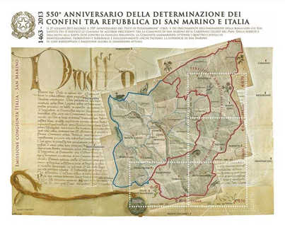
Pope Pius II in 1463 ratified the Pacts of Fossombrone with it the borders between the Republic of San Marino and Italy were defined.
Stamps show the vintage topographic map of the Republic of San Marino.
|
|
Send note to Staff
|
|
|
Pillar Of The Community
Slovenia
838 Posts |
|
|
Vatican City State
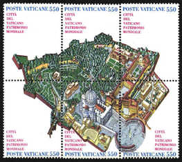
Vatican City State is a city-state whose territory consists of a walled enclave within the city of Rome. The state has an area of approximately 44 hectares and a population of around 840.
This makes Vatican City the smallest internationally recognized independent state in the world by both area and population.
The block of six stamps recognizes the World Heritage Campaign of the United Nations Educational, Scientific, and Cultural Organization. |
|
Send note to Staff
|
|
|
Pillar Of The Community
7838 Posts |
|
|
Map of Guanacaste Province, printed by lithography (American Bank Note Company), and issued by Costa Rica in 1924 to commemorate the centenary of the incorporation of this part of the Nicoya peninsula, Scott No. 130. - nethryk  |
|
Send note to Staff
|
|
|
Pillar Of The Community
Slovenia
838 Posts |
|
|
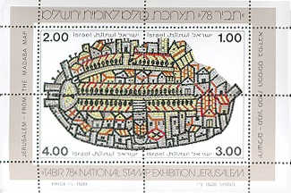
Madaba Mosaic Map
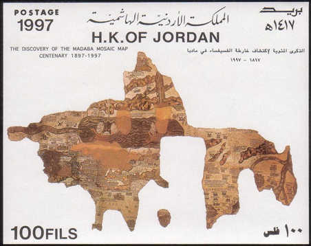
The Madaba Mosaic Map is part of a floor mosaic in the early Byzantine church of Saint George at Madaba, Jordan. It dates to the 6th century.
It is a map of the Middle East. Part of it contains the oldest surviving original cartographic depiction of the Holy Land and especially Jerusalem.
The mosaic was rediscovered in 1884, during the construction of a new Greek Orthodox church.
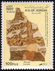 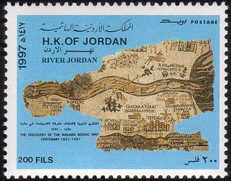 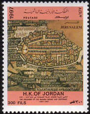
...................Karak....................................River Jordan......................................Jerusalem |
|
Send note to Staff
|
|
|
Valued Member
Netherlands
30 Posts |
|
|
Here are my contributions to this interesting topic : Dutch FDC commemorating 200 years Australia (issued 1988) Map of Australia with Nova Hollandia written on it. In The map at the left side of the fdc are various dutch names written like "Geelvinck Channel" and "Groote ylandt" 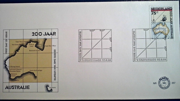 Dutch FDC issued in 1986 celebrating the completion of the Delta-works the famous dutch project to safeguard the south-west of the country against the north-sea floods , it was designed after the "North sea flood of 1953" and took years to finish and is still the largest man-made water barrier in the world. 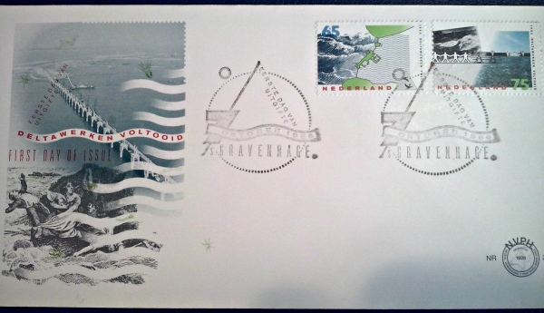 Belgian stamp issued in 1966 the map on this souvenir sheet is of the Belgian Antarctic Expeditions. 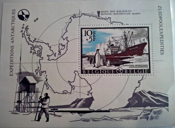 The Next sheet is from Saint-Pierre-Et-Miquelon , 6 small islands at the canadian coast, they are former French colonies. issued in 1989 (philexfrance) 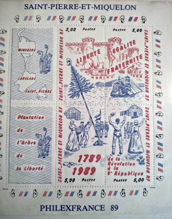 The following stamp is from Ivory Coast issued in 1965 in commeration of 5 years independence. The map shows the Ivory Coast. 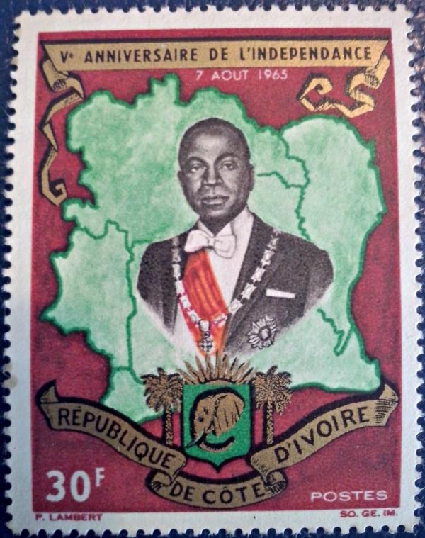 The last one is an English stamp, National productivity year 1962 series.  |
|
Send note to Staff
|
| Edited by TF1 - 03/31/2014 09:46 am |
|
|
Pillar Of The Community
Slovenia
838 Posts |
|
|
Madaba Mosaic Map II
The centre of Madaba Mosaic map was Jerusalem.
The map originally measuring about 24 by 6 metres and surrounded by a 75 centimetre wide scroll border.
It depicted the whole of biblical Palestine, reaching north to Hamat and Damascus,
east to Rabbat Ammon and Petra, south to the Nile delta, and west to the Mediterranean.see my post: https://goscf.com/t/947&whichpage=23#314198 |
|
Send note to Staff
|
|
|
Pillar Of The Community
7838 Posts |
|
|
Map of Western Samoa, designed by James Berry, engraved and printed by Bradbury, Wilkinson & Co., Ltd., and issued for use in Samoa on August 29, 1939 as one of a set of four stamps commemorating the 25th anniversary of New Zealand's seizure and occupation of German Samoa soon after the beginning of World War I, Scott No. 182. - nethryk  |
|
Send note to Staff
|
|
|
Pillar Of The Community
Slovenia
838 Posts |
|
|
Amber street
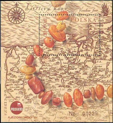
........ part of an amber necklace, map of the area of Gdansk
Abraham Ortelius (1527-1598) one of the most prominent geographers of the sixteenth century made the Theatrum Orbis Terrarum (Theatre of the World)
which is considered the first true atlas in the modern sense. It first appeared in 1570 and continued to be published until 1612.
During this period, over seventy-three hundred copies were printed in thirty-one editions and seven different languages. |
|
Send note to Staff
|
|
|
Pillar Of The Community
7838 Posts |
|
|
Antique Portuguese nautical chart (c. 1471) of Cape Verde Islands, printed by lithography, and issued for use in Cape Verde on February 24, 1952, Scott No. 277. - nethryk  |
|
Send note to Staff
|
|
|
Pillar Of The Community
Slovenia
838 Posts |
|
|
World Tourism Conference, Manila - 1980
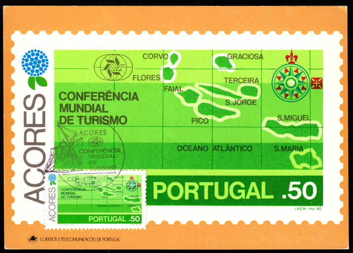 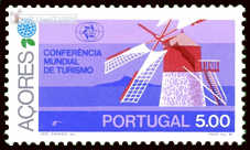
.........................................................................maximum card
.....................................................on special postmark is conference emblem: .............................................................................. windmill of Faial
The World Tourism Conference in 1980 held in Manila, Philippines.
Portugal issued 6 stamps, one of them shows map of Azores island, the second one windmill of Faial. |
|
Send note to Staff
|
|
|
Pillar Of The Community
Slovenia
838 Posts |
|
|
Old maps from Denmark 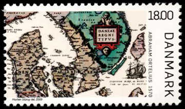 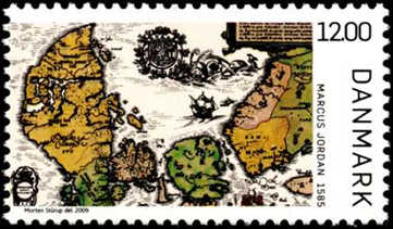 ...........................Abraham Ortelius ..................................................................Marcus Jordan ...........................Abraham Ortelius ..................................................................Marcus Jordan The first known printed map of Denmark was drawn up by the Dutch cartographer Abraham Ortelius (1527-1598) in 1570. He is author of the first modern atlas, Theatrum orbis terrarum (Theatre of the World). The Danish cartographer Marcus Jordan (1521-1595) made in 1552 a map of Danmark, which was based on his own measurements and observations. But the map not survived. On stamp is his map of Denmark from 1585. It is the oldest preserved map of Danish origin. 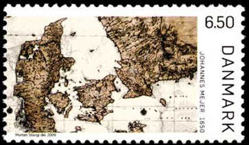 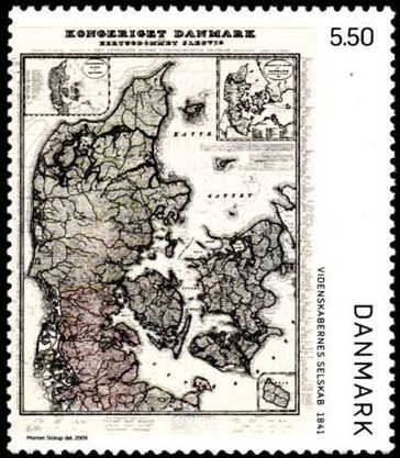 .............................Johannes Mejer ............................................................. Videnskabernes Selskab Johannes Mejer .............................Johannes Mejer ............................................................. Videnskabernes Selskab Johannes Mejer (1606-1674) was a geographer and mathematician. He has mapped Schleswig and Holstein in the years 1638 to 1648. For king Christian IV he made maps of Jutland, Danmark and Danish possessions in the current Sweden. Videnskabernes Selskab -The Royal Danish Academy of Science was founded in 1742 to promote science and technology. One of projects was to do the first real topographical maps of Danmark and its areas. about Abraham Ortelius see also my post: https://goscf.com/t/947&whichpage=23#316126 |
|
Send note to Staff
|
| Edited by primoz - 05/06/2014 3:24 pm |
|
|
Pillar Of The Community
7838 Posts |
|
|
Map of the Americas covered with shoe prints, airmail stamp designed by Mexican graphic artist Rubén García-Castro, printed by photogravure, and issued by Mexico on December 23, 1972 to promote tourism, Scott Np. C413. - nethryk  |
|
Send note to Staff
|
|
|
Replies: 643 / Views: 152,236 |
|


