| Author |
 Replies: 643 / Views: 152,253 Replies: 643 / Views: 152,253 |
|
|
|
Pillar Of The Community
United States
3222 Posts |
|
|
Pillar Of The Community
7838 Posts |
|
|
Here is an image of a stamp depicting the world map and heart-shaped emblem of the Academy of Overseas Sciences, designed by Jacques Combet (1920-1993), and issued by France on May 26, 1973 to commemorate the Academy's 50th anniversary, Scott No. 1375, Y&T No. 1760. Note: The four verbs inscribed on this stamp ("to love, "to know," "to understand," "to respect") comprise the motto of the Academy. - nethryk  |
Send note to Staff 
|
| Edited by nethryk - 06/20/2017 10:35 am |
|
|
Pillar Of The Community
7838 Posts |
|
|
"Economic Co-operation for World Peace:" Here is an image of an engraved stamp depicting a map of South East Asia, a ship, and the emblem of the Conference of the Commission on Asian and Eastern Affairs of the International Chamber of Commerce, and issued by Pakistan on December 5, 1960 to publicize the session, held in Karachi, Scott No. 120. - nethryk  |
|
Send note to Staff
|
|
|
Pillar Of The Community
United States
7239 Posts |
|
|
This 1998 Singapore stamp features a map showing Singapore as a member of the Malaysian Federation (1961-65). 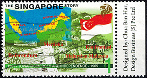 |
|
Send note to Staff
|
|
|
Moderator

United States
4788 Posts |
|
|
I'd love to have a high-resolution scan of Nells250's map!
If anyone has one, let me know. |
|
Send note to Staff
|
|
|
Pillar Of The Community
United States
7239 Posts |
|
|
This old cinderella (1890-1900) is an interesting piece of propaganda, and features a map. After the Dutch Afrikaaners had defeated the British in the first Boer War, it was obvious that the British were determined to wrest control of the South African Republic. This Cinderella depicts South African President Paul Kruger heroically holding up the country in one hand, and brandishing a club in the other hand. A Scotsman(?) has fallen into the ocean, and John Bull hangs on to Zululand for dear life. Storm clouds are on the horizon. The inscription reads "Unity is Strength". The label was printed in Germany (Scheunert - Leipzig). Kaiser Wilhelm gave vocal support to the Afrikaners. In the end, the British took Transvaal and Paul Kruger died in Switzerland in 1904. 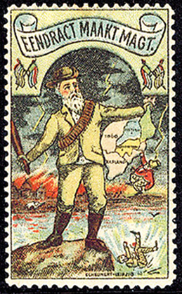 |
|
Send note to Staff
|
|
|
Pillar Of The Community
United States
7239 Posts |
|
|
Here is another propaganda label for the maps topic. This one is from Germany, and it says "The Saar remains German". It is die cut in the shape of a map of the Saarland. Size is 48mm wide by 50mm high. It celebrates the 1935 plebiscite referendum whereby the territory was returned to Germany by over 90% of the voters.  |
|
Send note to Staff
|
|
|
Pillar Of The Community
7838 Posts |
|
|
Map of the island of Anegada, engraved and printed by Thomas de la Rue & Co., Ltd., and issued for use in (British) Virgin Islands on April 15, 1952, Scott No. 105. - nethryk 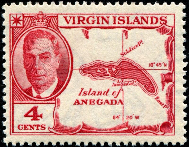 |
|
Send note to Staff
|
|
|
Pillar Of The Community
7838 Posts |
|
|
Map of Southeast Asia highlighting Vietnam (in yellow), printed by photogravure (Delrieu), and issued by Mali on November 2, 1964 to commemorate the solidarity campaign of the workers of Mali with the workers and people of South Vietnam, Scott No. 66. Note that although all of Vietnam is shown in yellow, the (then existing) dividing line between North and South Vietnam, located roughly at the 17th Parallel (the straight black horizontal line), is also indicated on this map. - nethryk 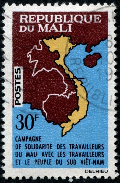 |
|
Send note to Staff
|
| Edited by nethryk - 05/19/2018 09:39 am |
|
|
Pillar Of The Community
United States
7239 Posts |
|
|
A map of the Netherlands lies in the background of this 2015 mailing label/stamp of private courier TNT Post. TNT Post is a business of TNT Express, which since May 2016 is a subsidiary of FedEx. TNT started out in 1947 as a shipping company in Australia. Through mergers and acquisitions it expanded to become a major shipper, and moved its headquarters to the Netherlands. Today it is one of the "big three" in the world: FedEx (including TNT), UPS (USA) and DHL (Germany). 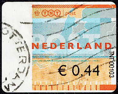 |
|
Send note to Staff
|
|
|
Pillar Of The Community
7838 Posts |
|
|
Pillar Of The Community
United States
7239 Posts |
|
|
Here is another private courier TNT Post "map" stamp from the Netherlands. This one has a billboard with a barely visible 2008 date on it, so one might presume it was issued in that year. The partial cancel on this stamp appears to say "TNT POST", whereas the more recent stamp (see 2 posts above, here) has a Netherlands Post "Rotterdam" roller/parcel cancel. 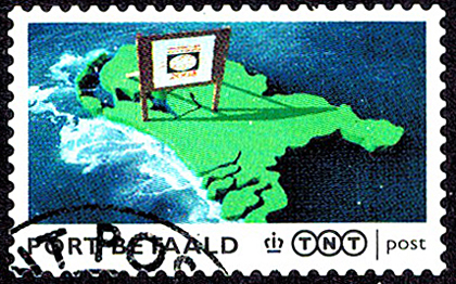 |
|
Send note to Staff
|
|
|
Pillar Of The Community
7838 Posts |
|
|
Here is an image of a stamp depicting a 16th century map of Japan, printed by photogravure, and issued by Japan on April 5, 1985 to publicize the World Import Fair Nagoya `85, Scott No. 1644. Bonus: Tall ship. - nethryk 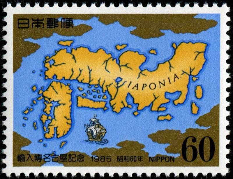 |
|
Send note to Staff
|
|
|
Bedrock Of The Community
United States
28693 Posts |
|
|
Bahamas 10th Anniversary of the Bahamas National Geographic Information System July 21, 2014 Set of four, two stamps depict GIS data displayed on a map of the Bahamas. 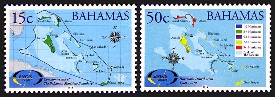 |
|
Send note to Staff
|
|
|
Bedrock Of The Community
United States
28693 Posts |
|
|
Romania National Museum of Maps and Old Books April 4, 2003 The minisheet reproduces a map Old description of Dacia by Dutch publisher Peter Kaerius (1571 c.1646). 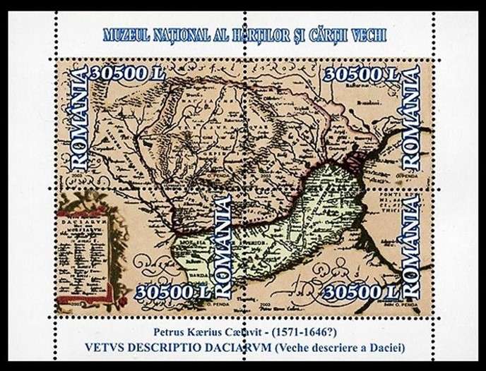 |
|
Send note to Staff
|
|
|
Replies: 643 / Views: 152,253 |
|