Stamp Community Family of Web Sites
Thousands of stamps, consistently graded, competitively priced and hundreds of in-depth blog posts to read


Stamp Community Forum
 
Username:
Password:
Save Password
Forgot your Password?

This page may contain links that result in small commissions to keep this free site up and running.

Welcome Guest! Registering and/or logging in will remove the anchor (bottom) ads. It's Free!

The Evolution Of Mr. Zip

 
To participate in the forum you must log in or register.
Author Previous TopicReplies: 4 / Views: 1,231Next Topic  
Bedrock Of The Community
United States
12128 Posts
Posted 11/09/2011   01:29 am  Show Profile Bookmark this topic Add wt1 to your friends list Get a Link to this Message
A fascinating read for anyone interested in the evolution of Mr. Zip (a/k/a Zippy), the mascot of the US Post Office from the 1960s through the 1980s when 5-digit ZIP Codes were in use:

http://www.postalmuseum.si.edu/zipc...aign/p1.html
Send note to Staff

Bedrock Of The Community
Australia
38679 Posts
Posted 11/09/2011   04:13 am  Show Profile Bookmark this reply Add rod222 to your friends list  Get a Link to this Reply

At first glance, an idea borrowed from "Monkey Magic"
but Mr Zip precedes that series by 18 years!
Monkey Magic was not shown in the US.

Send note to Staff  Go to Top of Page
Pillar Of The Community
United States
527 Posts
Posted 11/09/2011   9:16 pm  Show Profile Bookmark this reply Add lpmiller to your friends list  Get a Link to this Reply
I was just a little kid when the ZIP code system came in. I was curious about the previous system. The article alludes to it, but doesn't describe the construct of the system. From what I can find from Googling it, it looks like it was a two digit number placed after the city name and before the state name. For example, my home town would have been identified as "San Angelo 76, Texas." I believe it was about this same time that a standardized two-letter system was established to identify specific states on correspondence. I hope some of you more senior philatelists will correct me on these if I'm wrong.

Larry
NN16 9UW (just curious if any readers can identify this code)
Send note to Staff  Go to Top of Page
Bedrock Of The Community
United States
12128 Posts
Posted 11/10/2011   12:10 am  Show Profile Bookmark this reply Add wt1 to your friends list  Get a Link to this Reply

Quote:
NN16 9UW (just curious if any readers can identify this code)

A Google search reveals that postal code to be from England, specifically:

Quote:
Weekley
Kettering, Northamptonshire NN16 9UW, UK


As for the Postal Zones implemented in the US in 1943:


Quote:
I was curious about the previous system. The article alludes to it, but doesn't describe the construct of the system. From what I can find from Googling it, it looks like it was a two digit number placed after the city name and before the state name.


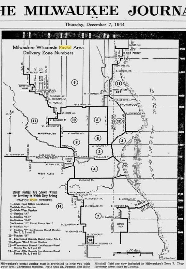
Essentially correct. It was either a 1 or 2 digit code, implemented in only 178 major cities in the US. Smaller cities and towns did not have such codes until the introduction of ZIP Codes in 1963. The reason for the 1943 Zone Codes was due to the war effort having taken many of the seasoned postal clerks from their duties and substitute clerks were having trouble identifying the location of certain zones within larger cities, so the plan was introduced.

As I understand it, there were postcards sent out at the time to all citizens and there were zoning maps by city that helped to identify proper zones within a city, but it took quite awhile for the general public to get used to it, so implementation was gradual.

As for the standardized 2 letter State abbreviation, it was introduced in conjunction with ZIP Codes in 1963, but hadn't taken on full use until the 1970's, when computerized mailing equipment was fully implemented. It has been suggested that NY, NC, NJ, etc. were always two-letter abbreviations, but states such as Mass., Conn., Fla., Penna., Nebr., were often extended beyond the two letters for some years after.

I hope this information is helpful.

[edit] It would be too much to provide all of the Postal Zoning Maps, but here's an example published in the Milwaukee Journal from December 7, 1944 that shows the Zones established for that city:

Send note to Staff  Go to Top of Page
Edited by wt1 - 11/10/2011 12:50 am
Valued Member
United States
302 Posts
Posted 11/11/2011   7:21 pm  Show Profile Bookmark this reply Add panda.bear to your friends list  Get a Link to this Reply
A nice exhibit - thanks for sharing.
Send note to Staff  Go to Top of Page
  Previous TopicReplies: 4 / Views: 1,231Next Topic  
 
To participate in the forum you must log in or register.

Go to Top of Page

Disclaimer: While a tremendous amount of effort goes into ensuring the accuracy of the information contained in this site, Stamp Community assumes no liability for errors. Copyright 2005 - 2026 Stamp Community Family - All rights reserved worldwide. Use of any images or content on this website without prior written permission of Stamp Community or the original lender is strictly prohibited.
Privacy Policy / Terms of Use    Advertise Here
Stamp Community Forum © 2007 - 2026 Stamp Community Forums
It took 0.3 seconds to lick this stamp. Powered By: Snitz Forums 2000 Version 3.4.05