|
This page may contain links that result in small commissions to keep this free site up and running.

Welcome Guest! Registering and/or logging in will remove the anchor (bottom) ads. It's Free!
To participate in the forum you must log in or register.
| Author |
 Replies: 49 / Views: 20,489 Replies: 49 / Views: 20,489 |
|
|
|
Pillar Of The Community
Canada
1084 Posts |
|
|
In another thread I said that part of my stamp collection consisted of stamps given to me by people who had quit collecting. On a geographic basis, the postmarks on these stamps clustered around certain areas of southwestern Ontario. The only exception, distance-wise, were cancelled stamps, and often postcards, from southern Saskatchewan and Manitoba in western Canada and North Dakota in the U.S. Typically these were from relatives who went west (most likely sons from large families) on promises of free or cheap tree-less land. As years passed trips would be made west to visit relatives and help "with the harvest" and some would stay there. I have heard of instances of the reverse happening in that the westerners would head east in early spring when the sap was running and go back west with a load of maple syrup. In time though the family trees essentially split because of distance. Having said all that here is an image (see below) of a stamp (Canada Scott#35) that is postmarked Pinkerton. Pinkerton, along with Cargill and Chepstow, are pretty little villages located on the Teeswater River a few miles upstream from where it joins the larger Saugeen River at the above-mentioned Paisley. They are located where they are for one reason: water-power to run gristmills and sawmills. I could be wrong but the mill in Pinkerton may still operate using water as its motive-power. For those interested the grand-daddy of all such mills is Stark's Mill located downstream at Paisley. The Pinkerton Post Office opened in 1860 and for a many years had a number of postmasters including various members of the Pinkerton family. In 1925 Herbert Leroy Cramm became postmaster and held that position until he retired in 1965. Donald Cramm then held the position until the post office was closed in 1969. There is a great deal of confusion in the postal history between Pinkerton and Eden Grove, which is located about 1.25 miles to the east. Eden Grove had its own post office (also a dpo) and was on the Wellington Grey & Bruce railway line (later the Grand Trunk and still later Canadian National). The railway timetables, however, referred to the Eden Grove stop as "Pinkerton Station" so one has to keep in mind that Pinkerton Station was not in Pinkerton but Eden Grove. Canada Scott#35 Pinkerton Postmark/Cancel 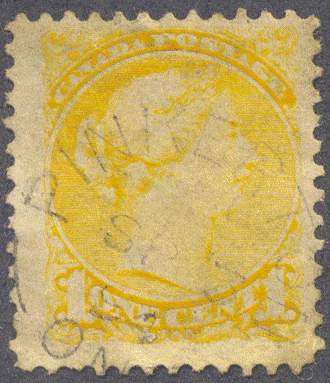 The Google Maps image below shows the geographic relationship between some of the communities mentioned: Pinkerton-Eden Grove-Cargill 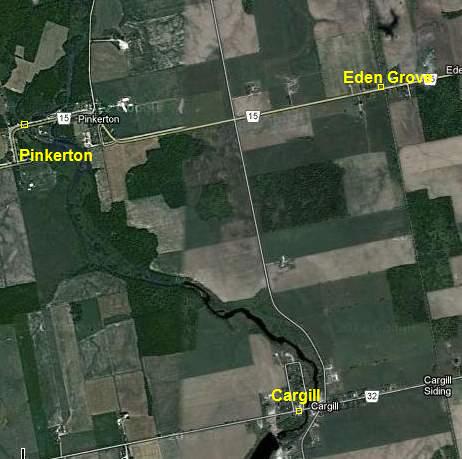 Pinkerton has been subsumed by modern civic planning in that it is now part of a larger municipality called Brockton. Below is a view of the general store that I believe was the post office when Mr. Cramm was postmaster. Bruce County Village of Pinkerton, Municipality of Brockton 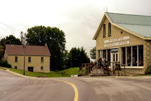 |
Send note to Staff 
|
| Edited by cynical - 11/05/2012 08:55 am |
|
|
Pillar Of The Community
Canada
1084 Posts |
|
|
It was my intention to go from Pinkerton to Eden Grove next but given that I have inserted the map above l'm going to get you there in a round-about way. Leaving Pinkerton we will walk by Senator Donnelly's house (famous area lumberman, "rancher", politician). http://en.wikipedia.org/wiki/James_J._DonnellyA jog or two and we turn south to walk along the road to Cargill. To our right is a sugar maple bush, which appears from the photo to have been cut back a bit recently (a guess on my part) but, in times past, probably provided a lot of maple syrup. Up ahead the road bends left (east) to avoid a meander in the Teeswater River. Using the web we will occasionally slip into the past from here on. Just to our left was a "field of "dreams" for the "boys of summer", who after haying or threshing would come here to play "ball" but that was half a century ago. Cargill has since built itself a brand new park on the south side of the village (see map above). Still on our left we pass the Dales farm, which, until recently, had the largest barn in Bruce County but it's now gone. A few hundred feet more and we are at the Silverwoods Creamery corner in Cargill. I've brought you this far to show you an important piece of postal history so let's turn right and walk up the main street to the west end of the village where we will see this house on the north side of the street: Henry Cargill House, Municipality of Brockton, Bruce County 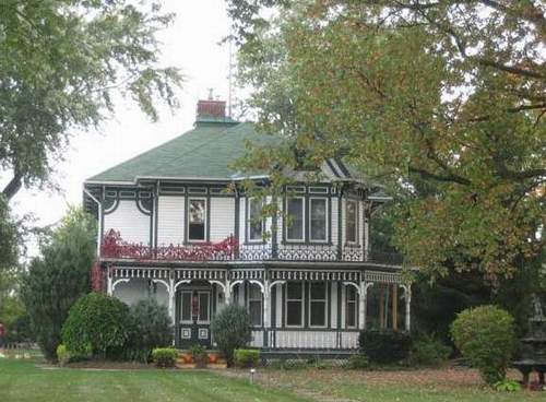 That house belonged to the Postmaster, who went on to become Senator Henry Cargill. However, he didn't become senator because he was the village's first postmaster for seven years (1880-1887). No, his life was entwined with the enormous Greenock Swamp located a few miles southwest of the village he founded. Here is a small portion of his biography from the Dictionary of Canadian Biography Online: Quote:
Cargill now faced the task of developing the swamp. The first step was to construct corduroy roads into the area and dig canals, which allowed logs to be floated out and helped to drain the land. The latter function was important because the cleared land could then be sold as farmland. The logs were taken via the Teeswater River to the mill complex Cargill had purchased from Mickle. Originally called Yokassippi and later Mickle Station, this small village, which was situated on a division of the Great Western Railway, was soon renamed Cargill. The extensive manufacturing base built up by Cargill included a planing mill, a stave-mill, and a heading mill; he also operated a general store and opened a woollen mill. His aim was not only to utilize the full resources of the swamp but also to provide long-term employment. Cargill's concern for the local people was also reflected by his provision of a waterworks, fire equipment, a powerplant to provide electricity, and a school; he was generous too in helping to pay for the construction of local churches (Cargill himself was a Presbyterian). The village, which had a population of 200 in 1885, was labelled by the Farmer's Advocate and Home Magazine "one of the most prosperous in the Province" and Cargill was hailed for establishing a model of labour relations and capital development. Cargill is not yet a "dead post office" village so this has been a bit of ruse to introduce you to Cargill's first postmaster. As far as I can tell I don't have a cancelled stamp or cover from Henry Cargill's tenure but I have a few that were cancelled when his replacement, Charles W. Keeling, had the job (here's one of them below). Cargill Postmark/Cancel on 3c Small Queen 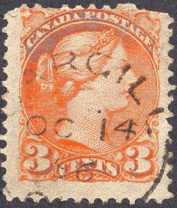 Now that we've seen Henry Cargill's house let's turn around and head back through the village in the direction of the railway station (Cargill Siding), which is located beyond the community limits in adjacent Brant Township. No walking this time though. The coal dealer is headed out there and offered us a ride behind his beautiful team of Clydesdale horses (get it - "teamster"). At the station ("the depot") his coal car is sitting on the siding waiting to be emptied and picked up by tomorrow's way freight. If he fails to empty it by then there will be demurrage. This neat little station (possibly a variation on the Grand Trunk's Class E style station) is where the bagged Cargill mail was put off from the Wellington Grey & Bruce/Grand Trunk/CNR train and Acknowledgement Receipts and Letter Bills exchanged between the Postmaster and the Harrisburg&Southampton mail car. A lot of mail moved through here and most of it was generated by Henry Cargill's mills. Cargill, Ontario, Grand Trunk Train Station About 1911 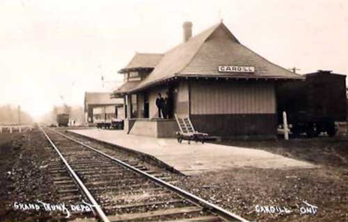 If you are interested in train stations the above photo is from this fantastic site: http://www.canada-rail.com/about/index.htmlThe next train will be the Palmerston-Southampton night train which is many hours away so let's walk the tracks north to Eden Grove. It's only 1.25 miles but first a warning. If you have never walked tracks before be aware that they can drive you nuts - your pace will be longer than the distance between the ties. |
|
Send note to Staff
|
| Edited by cynical - 12/08/2012 07:02 am |
|
|
Pillar Of The Community
Canada
1084 Posts |
|
|
We have arrived at our destination, Eden Grove, having got here by walking north from Cargill Siding using the railway tracks. Railway tracks and depot yards are dangerous places as attested to by the following item from the Paisley Advocate (February, 1950): Quote:
John Cruickshank, 87 year old former resident of Greenock Twp. and Paisley, who for the past several years has made his home at Eden Grove, was instantly killed Wednesday afternoon at 1:25 pm, when hit by a southbound CNR freight. The accident occurred at the railway crossing 100 ft directly south of the Pinkerton depot, and within sight of the Cruickshank residence. The aged man was walking east on the highway on his way to get the mail at the post office in Scott's General Store, and apparently failed to either see or hear the approaching freight train as it passed through the depot yards without stopping. Mr. Cruickshank walked almost directly into the path of the train which was travelling about 15 miles an hour. The Eden Grove Post Office opened in 1875 and closed in 1969. The only Eden Grove postal item that I have is a post card addressed to there but its stamp has either dropped off or been removed. I do, however, have an image of a "letter bill" receipt that passed between the Pinkerton and Eden Grove post offices that shows their respective postmarks in their appropriate boxes for April 9, 1895 (see below). 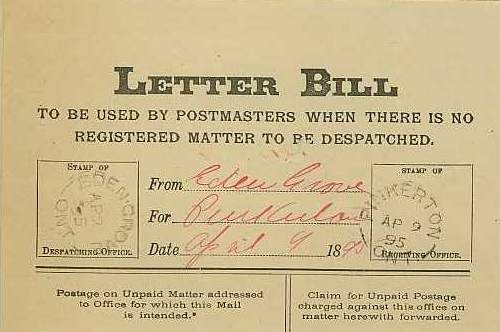 |
|
Send note to Staff
|
|
|
Pillar Of The Community
Canada
1084 Posts |
|
|
Before we leave the Pinkerton area I should mention another discontinued post office (dpo) that was about 2 miles northwest of the village as the crow flies. This was the hamlet of Portal, whose post office opened in 1894 and closed in 1914. The only evidence I have for its existence is a web image of a letter bill receipt exchanged between its postmaster and the Pinkerton Postmaster: 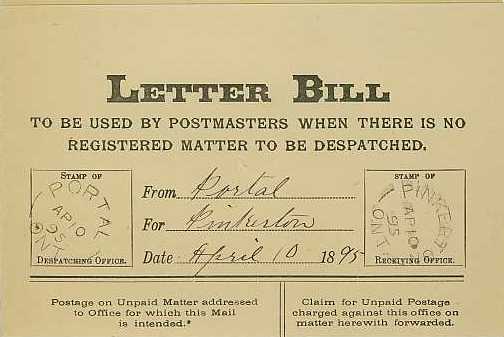 |
|
Send note to Staff
|
|
|
Pillar Of The Community
Canada
1084 Posts |
|
|
A majority of the post offices I have looked at so far have been in Bruce County's Greenock Township. Using my Illustrated Atlas of the County of Bruce (1880) in conjunction with the Post Offices and Postmasters database at Collections Canada I notice that most of the township's post offices have, over the years, closed. In addition to the ones mentioned above the others that are gone are Riversdale, Bradley, Greenock (Enniskillen) , Narva and Glammis. I was convinced I had a Greenock and Riversdale postmark but if I have I couldn't find them. I believe Cargill and Chepstow are still open but they may have become "franchise" offices. |
|
Send note to Staff
|
|
|
Pillar Of The Community
Canada
1084 Posts |
|
|
The postal hamlet of Williscroft was located a few miles northeast of Paisley in Bruce County's Elderslie Township. Its slow demise was instigated by the closure of the post office when the area converted to rural mail delivery in 1913. Below is a 1-split-ring (broken circle) receiving mark on the pictorial part of a postcard that is dated May 23, 1912: Williscroft, Ontario, 1-split-ring receiving mark dated 1912 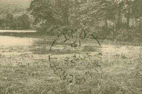 Edit: after many months of searching I have found a Williscroft 2-split-ring postmark with a manuscript date showing the 10th of October 1868, which is still some time after the post office opened in 1856. The image (see below) is from The History of Elderslie Township: 1851-1977. The postmaster from opening day and for almost the next 25 years was none other than George Williscroft himself and there is a pretty good chance that he is responsible for this very mark: 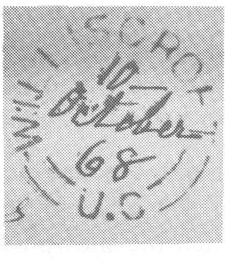 |
|
Send note to Staff
|
| Edited by cynical - 11/12/2013 8:48 pm |
|
|
Pillar Of The Community
Canada
1084 Posts |
|
|
Heron Bay South was located a short distance upstream from where the Pic River entered Lake Superior near present-day Pukaskwa National Park. The community became established in the late 1930's around an elevated flume that was erected to carry pulp-wood logs from the nearby Black River to the Pic River. The wood was then loaded onto lake boats and shipped across the lake to a mill in Wisconsin. This operation lasted into the mid-1960's and Heron Bay South's demise began thereafter. It is now a ghost town with nothing remaining but a few road remnants. 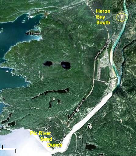 The Heron Bay South Post Office opened in 1939 and closed in 1970. Below is a postmark/cancel for this now "dead post office" (dpo). Canada Scott#361 1956 5c Mountain Goat with Heron Bay South cds cancel 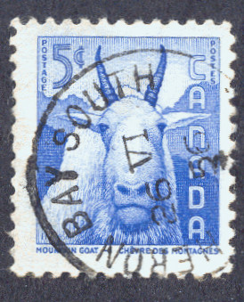 |
|
Send note to Staff
|
|
|
Pillar Of The Community
Canada
1084 Posts |
|
|
A few miles east of Orillia, Ontario, on the north side of Lake Simcoe is the small community of Uptergrove, which is now part of the relatively new Municipality of Ramara. Avid readers may know Orillia as the home of famous author, humourist, historian and economist, Stephen Leacock (1969 Canada Scott#504) but probably don't know of Uptergrove. Its post office, which opened in 1870, closed in 1965, giving its postmarks/cancels "dpo" status. Canada Scott#387 St. Lawrence Seaway - Uptergrove cds cancel 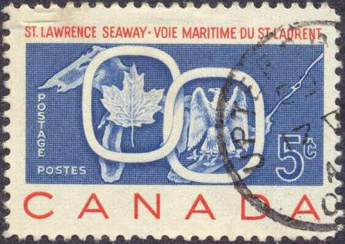 |
|
Send note to Staff
|
|
|
Pillar Of The Community
Canada
4648 Posts |
|
|
The last time I was through Uptergrove has to be close to 10 years ago. It can be any bigger than a small hamlet and on a corner-roads intersection. There is interesting scenery around the area.
Chimo
Bujutsu |
|
Send note to Staff
|
|
|
Pillar Of The Community
Canada
1084 Posts |
|
|
Came across this postcard today on ebay showing the Grand Trunk Railway (GTR) trestle (bridge) over the Teeswater River at Paisley Ontario. The Ellengowan postmark, the Walkerton transit mark and the Solway receiver mark are of interest in that the three post offices are not very far apart, in fact, they are in the same Township of Brant. Looking them up on Google Maps will show the round-about route the post card took. Two of the three post-offices are dead post offices (dpo), having closed over a hundred years ago. The Ellengowan Post Office opened in 1858 and closed in 1910. The Solway Post Office opened in 1877 and closed in 1913 with the arrival of rural mail delivery. Grand Trunk Railway Trestle Over Teeswater River at Paisley Ontario 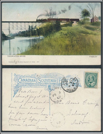 Edit: found this same postcard elsewhere on the web along with some others showing this same bridge at the link below: http://www.deeprootstalltrees.com/P.../Bridges.htm |
|
Send note to Staff
|
| Edited by cynical - 12/13/2013 4:35 pm |
|
|
Pillar Of The Community
Canada
1084 Posts |
|
|
Here is another postcard that I noticed on ebay today. I'm starting to detect a pattern here. This card centres on the same general area as my previous post but this one shows the main street of Chesley, Ontario, located in Bruce County's Elderslie Township. The card is postmarked Marmion, which is located in adjacent Sullivan Township, south-west of the Village of Chatsworth between Dobbinton and Desboro in Grey County. The Marmion Post Office opened in 1858 and closed in 1959. The destination of the card is to the same, long-gone, postal hamlet of Solway described above as having closed in 1913. Postcard Chesley, Ontario, Main Street Marmion to Solway dpo 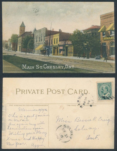 |
|
Send note to Staff
|
|
|
Pillar Of The Community
Canada
4648 Posts |
|
|
A great card Cynical.
Like you, I find it interesting to get old cards showing the same building or group of buildings, but, from a different perspective.
I also like the clear "Split-Ring" strike from Solway too. I wish all mail had cancels that clear.
Chimo
Bujutsu |
|
Send note to Staff
|
|
|
Pillar Of The Community
Canada
1084 Posts |
|
|
For quite some time in the 1960's Max Rosenthal wrote a column in BNA Topics that outlined the postal history of the various counties and districts in Ontario. One such piece was entitled "Early Post Offices of the Midland District". He had this to say about the Flos Post office located in Flos Township, Simcoe County, and, by association, the later Craighurst Post Office (BNATopics, 1965, v22, n4, April). Quote:
In 1832 Hugh Marlow took up a lot on the Penetanguîshene Road about a mile north of Hillsdale, in Medonte, but in a couple of years he moved to the Flos side, a quarter mile west of the future village of Hillsdale, where he kept a store, tavern and, beginning in 1837, Flos post office. In the l840's Flos Post Office was moved south towards Craíghurst, at the very southwest corner of Medonte. James Morrison kept the first tavern there, and it was called Morrison's Corners. He started the line of stages along thc Penetanguíshane Road in 1847.
Thomas Craig had taken up land 3/4 of a mile north of this corner in 1818. His eldest son, John Craig, became postmaster when Flos post office was moved there. John Hunter. the first mail carrier from Barrie to Owen Sound, in writing his reminiscences of May 184?, mentions a strict surveillance kept at Flos post office, because of complaints about service. Speaking of carrying the mail from Barrie north on the Penetanguíshene Road at that time he wrote: "John Craig was postmaster, and had the office where he lived, 3/4 of a mile north of the corner (Craighurst) and I well remember that if 1 was a minute late I had to account for it. These were days before cheap postage."
James Patton, who laid out the southeast quarter of the site in village lots, named it after Craig, and about 1860 the post office name was changed from Flos to Craighurst. The Craighurst post office was moved West across the present Highway 93 into Flos Township in the 1890's. A tavern-keeper, Alexander Hill, was prominent at the time the Hillsdale post office was established near the original site of Flos, around 1870, and his name was used. It was in Medonte, at the corner of the 5th sideroad and Highway 93. Yesterday I came across this image (see below) on ebay that should make postal history buffs salivate. The stampless folded letter was posted from the above-described Flos Post office at a time when from here west across the Dundalk Highlands through the two counties of Grey and Bruce to Lake Huron there was nothing but bush. In fact, it was called "The Queen's Bush". Stamped with a lovely red 2-split-ring postmark with a manuscript date of April 7, 1848, the letter arrived in Portobello, Scotland, in the middle of May with an appropriate transit and receiver mark. The cost - one shilling and two pence sterling, which was the over the ocean rate at that time. Stampless Letter Flos Post Office to Portobello, Scotland 1848 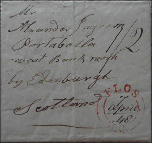 Stampless Letter Back Flos Twp to Portobello Scotland 1848  |
|
Send note to Staff
|
|
|
Pillar Of The Community
Canada
1084 Posts |
|
|
In the post above I made reference to the Queen's Bush and highly recommend the book of the same name for those interested in the struggles of early pioneers. While perusing covers on Don Slaughter's web site I noticed one that relates to this theme. Bosworth, located in Wellington County just a few miles northeast of Drayton, Ontario, is not only in the middle of the Queen's Bush but also on the periphery of the above-mentioned Dundalk Highlands (a.k.a., the Dundalk Till Plain or Dundalk "Island"). Given its high elevation the area has also been described as the "roof of peninsular Ontario" (i.e., southwestern Ontario). The major rivers of southwestern Ontario, such as the Maitland, Saugeen, Grand and the Nottawasaga flow out from this upland area. The Bosworth area itself is on a "fluted till plain" consisting of a faint nnw-sse pattern of drumlinoid ridges and swells that were created by glacial ice moving through from the northwest more than 10,000 years ago. Compared to surrounding areas further down-slope this elevated plain experiences cooler temperatures and, accordingly, a shorter growing season, which limits the number of crops that can be grown here successfully. For this reason it was one of the last areas to be cleared and settled. In the early decades of clearing land in this area (i.e., post-1840s) the major use by settlers of the postal system was correspondence involving the regional Crown Land offices. Once your oxen team (much preferred over excitable horses) had managed to pull out most of the stumps it was time to think about seed, which led to the next category of correspondence, namely, with seed companies. Major centres here are typically tied to the railway lines that were all shut down around 1960 or shortly thereafter. The many village names seen on the National Topographic System maps (NTS) are in fact just that - names of old postal hamlets that lost their post offices typically around 1913 when rural delivery was initiated in many of these areas. Bosworth became a discontinued or dead post office (dpo) at the end of 1914. The registered Rennie's Seeds return envelope supports a three-cent small Queen Victoria stamp (I assume Canada Scott#41) along with a couple of two-cent Queen Victoria numerals (Canada Scott#76) that was posted on February 13, 1899, allowing an appropriate amount of time until spring planting. Just to be on the safe side wax was added to ensure the seal. Reputations were at stake because the last thing a farmer wanted to hear was that he was always the last one to get "on the land". A buggy or wagon ride to the nearby Drayton train station and the cover was headed down the line as evidenced by the Harrisburg & Southampton mail car rpo hammered on to its back-side. 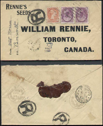 |
|
Send note to Staff
|
|
|
Pillar Of The Community
Canada
1084 Posts |
|
|
Given the season ("Xmas") I'm glad I saw this map-stamped cover (Canada Scott#86-see below) on ebay this morning as its sale expires in a few hours. You would be hard-pressed to find anything about Fyfield on the web, in a book or on a map. It was a postal hamlet as Collections Canada indicates the Fyfield Post Office opened in 1884 and closed on June 30, 1900, possibly making this cover the Last Recorded Date (LRD). The clue to its location lies in the Teeswater transit stamp on the back. Teeswater is in Culross Township, Bruce County. The only map I could find showing Fyfield on it was in the book entitled The History of Bruce County by Norman Robertson (see below). 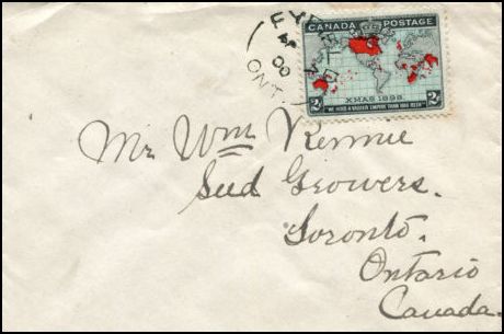 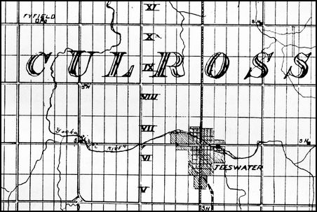 This letter would have made its way to Teeswater by horse and buggy, and eventually be put on CPR's Teeswater-Orangeville train and then on to the Owen Sound to Toronto train and its all downhill from there. |
|
Send note to Staff
|
|
|
Replies: 49 / Views: 20,489 |
|
|
To participate in the forum you must log in or register. | |
Disclaimer: While a tremendous amount of effort goes into ensuring the accuracy of the information contained in this site, Stamp Community assumes no liability for errors. Copyright 2005 - 2026 Stamp Community Family - All rights reserved worldwide. Use of any images or content on this website without prior written permission of Stamp Community or the original lender is strictly prohibited.
Privacy Policy / Terms of Use Advertise Here |
| Stamp Community Forum |
© 2007 - 2026 Stamp Community Forums |
| It took 0.23 seconds to lick this stamp. |
 |
|
|
|


