| Author |
 Replies: 41 / Views: 9,043 Replies: 41 / Views: 9,043 |
|
Rest in Peace
Canada
5701 Posts |
|
|
Does anyone know why Scott lists the capital of Eastern Silesia as Troppau (now called Opava). Troppau was located in Czech Silesia (orange on my map) which was included in the original Czech borders of 1918. I don't think that area was in dispute, though I may be wrong here. It is my understanding that Eastern Silesia is the name given for Cieszyn Silesia (green), which was in dispute between Czechoslovakia and Poland. It was the area of the planned but aborted plebiscite. This is where the stamps were intended for. I wonder if it even had a capital.  |
|
Send note to Staff
|
|
|
|
|
|
Pillar Of The Community
1448 Posts |
|
|
Rest in Peace
Canada
5701 Posts |
|
|
Thanks JKJ. I have been to that excellent page. I will be basing my map map on the town names he listed.
I tried contacting Lubor Kunc, but the email address is no longer valid.
When you were in Victoria, I was actually down your way on business, near Eugene. |
Send note to Staff 
|
|
|
|
Rest in Peace
Canada
5701 Posts |
|
|
Here is a Wikipedia map of Eastern Silesia by Piecyk Gazowy, which is free to share. It shows the final border agreed by Czechoslovakia and Poland. 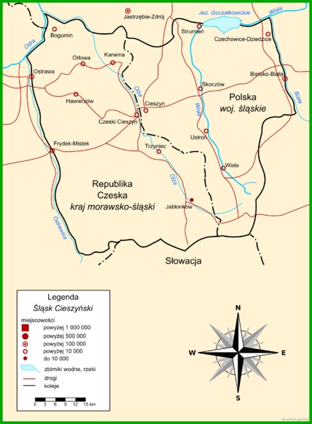 |
|
Send note to Staff
|
|
|
|
Pillar Of The Community
1448 Posts |
|
|
Quote:
When you were in Victoria, I was actually down your way on business, near Eugene. Some day we will meet!  Bee See - your maps are a work of art- and very accurate.  |
|
Send note to Staff
|
|
|
|
Valued Member
Japan
165 Posts |
|
|
Rest in Peace
Canada
5701 Posts |
|
|
Thank you Prahanoaki! Your information is very timely, as I have only recently "discovered" Spis and Orava. I have been drawing a map of the area, and attach a capture in its very preliminary stage. As you suggested, very little is available in English on the internet. I had not seen that article in Chechout, so a big thanks for the link. Anything in the Czech language I have found did not translate well with Google, but I have slowly been piecing together information. Finding this Trstena cancel from Orava led me to further research on the Spis Orava area.  The shaded area was the proposed plebiscite area. I will upload a better map when completed.  |
|
Send note to Staff
|
|
|
|
Valued Member
Japan
165 Posts |
|
|
wow! Excellent map you are making! I will take a picture of the pages of the Polish catalog Fischer Tom II to help you as soon as I get home tomorrow and send you. Its in Polish but I think there are few pages about SO 1920 with some maps, list of post offices and some example of rare cancels, but only about the Polish side... its a Polish catalog after all. Here is another article of Czechout talking about the use of SO 1920 outside of the plebiscite zone. Interesting! : http://www.czechout.org/journal/147.pdf#page=10Its in Czech but found a nice article about TPO used in the plebiscite zone but not surprisingly only the Czech side... https://www.yumpu.com/sk/document/v...telie-klim/5 |
|
Send note to Staff
|
| Edited by Prahanoaki - 11/25/2015 08:40 am |
|
|
Rest in Peace
Canada
5701 Posts |
|
|
More excellent information Prahanoaki.
As for the SO 1920 used outside of the plebiscite zone article, I found another one not listed in the article, Spisska Bela. When I scan it, I will display it.
|
|
Send note to Staff
|
|
|
|
Rest in Peace
Netherlands
153 Posts |
|
|
Nice work on the maps. Do you publish these somewhere online? Would love to see more of your fine work. As for Ostrova and Spis, here's a link to a Wikipedia entry that might be of interest: https://pl.wikipedia.org/wiki/Plebi...szu_i_OrawieGoogle translate does little for the text but the map is what I'm pointing at. It shows somewhat different borders for the referendum than the Czechout Journal. Borders that would actually include Spisska Bela. |
|
Send note to Staff
|
|
|
Rest in Peace
Canada
5701 Posts |
|
|
Thanks SWH.I had not seen that Wiki page. I will have to adjust the borders on my map. No, I have not published my maps yet, but plan to do so. I still have quite a bit of information to add, more and more keeps coming in, including what you have provided.  |
|
Send note to Staff
|
|
|
|
Rest in Peace
Netherlands
153 Posts |
|
|
I'll be looking forward to your publishing the maps. I do a bit of map making myself and am always eager to learn from others. There's not that many good maps with a philatelic perspective around.
BTW: I did not necessarily want to suggest you change the borders on your map. Just wanted to provide another resource - and thus I guess the dilemma which resource to follow. |
|
Send note to Staff
|
|
|
Rest in Peace
Canada
5701 Posts |
|
|
Quote:
BTW: I did not necessarily want to suggest you change the borders on your map. Just wanted to provide another resource - and thus I guess the dilemma which resource to follow. No problem! I was going to adjust my borders anyway. My border was closer to the one on the page you linked - I just was not sure if Spisska Bela was in the plebescite area. I will continue to do more research and will update the map as evidence comes in. Some of my information comes from this interesting document (non-philatelic), The SlovakPolish Border, 1918-1947, by Marcel Marcel Jesensky: https://www.ruor.uottawa.ca/bitstre...2_thesis.pdfIt includes several maps, but few villages on the Slovak side are indicated. |
|
Send note to Staff
|
|
| Edited by BeeSee - 11/25/2015 4:07 pm |
|
|
Rest in Peace
Canada
5701 Posts |
|
|
Here is something I just found in English, from the Society of Czech Philatelists: http://index.csphilately.org/2001_01_JanFeb.pdfGo to the article Formation of the Borders of Slovakia and Poland, by Jozef Tekel. The is plenty of information, including a part stating that the Plebiscite Commissioner for Spis had his office in Spisska Bela, which would indicate it was within the plebiscite area. The Commissioner for Orava was in Trstena, which we already new was in the plebiscite area of that territory. |
|
Send note to Staff
|
|
|
|
Rest in Peace
Netherlands
153 Posts |
|
|
Great resources you have found. Particularly the second offers great detail. On page 19 of the PDF the post offices in the plebiscite areas are listed. I checked these against the maps in the Czechout Journal and all are within the borders as indicated on those maps. While some of the towns just outside these borders are not on the list. Which would suggest that the borders as indicated in the Czechout Journal may be fairly accurate. At least more accurate than the borders in the Wikipedia entry I posted which include towns not on the list.
Also on that page it says that the SO issues were valid not only in the plebiscite areas but in all of Poland and Czechoslovakia. Which would explain the use outside of the plebiscite areas.
I am getting more and more curious what the outcome of your research will be. I'll definitely have to adjust my own maps of Poland and Czechoslovakia as the resources I used for those did not indicate the Ostrava and Spis areas to be split between the two, just the part that went to Poland. |
|
Send note to Staff
|
|
|
Pillar Of The Community
Czech Republic
623 Posts |
|
|
Replies: 41 / Views: 9,043 |
|


