| Author |
 Replies: 341 / Views: 110,752 Replies: 341 / Views: 110,752 |
|
|
|
Bedrock Of The Community
United States
28583 Posts |
|
|
Chile 2008 Easter Island Easter Island is located in the southeastern Pacific Ocean, on the border between the Pacific Plate and the Nazca Plate. It comprises three coalesced extinct volcanoes, one of which, Rano Kau, has a crater lake encircled by steep basalt cliffs. 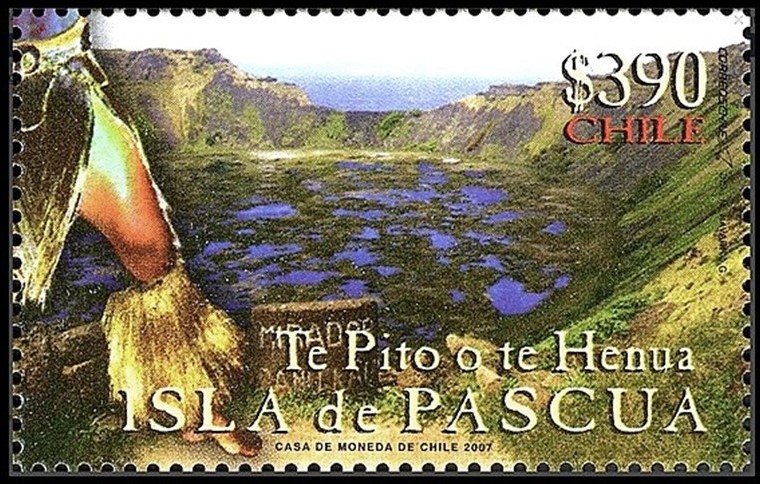 |
Send note to Staff 
|
|
|
Bedrock Of The Community
United States
28583 Posts |
|
|
Ecuador 2017 Darwin and Wolf Marine Sanctuary The Galapagos islands and seamounts are created by a mantle plume (hotspot) underneath the Nazca Plate since 20 million years ago. Darwin Island and Darwin Arch are located at the northern end of the archipelago. The 15 meter-high natural lava arch collapsed in 2021. 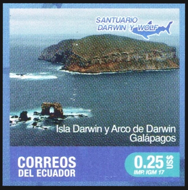 |
|
Send note to Staff
|
|
|
Bedrock Of The Community
United States
28583 Posts |
|
|
Peru 1987 75th Anniversary of the Discovery of Machu Picchu Machu Picchu (elevation 2430 m) is located in the Cordillera Oriental of southern Peru. It is one of the Permo-Triassic granitoid batholiths which became exposed as a result of Andean convergent deformation during Eocene. The bedrock of the Inca citadel is composed of granite and granodiorite. 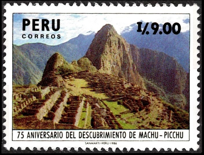 |
|
Send note to Staff
|
|
|
Bedrock Of The Community
United States
28583 Posts |
|
|
Peru 2009 Cumbemayo Archeological Site Los Frailones (stone monks) stand above the plains around Cajamarca in northwestern Peru. These massive stone pillars are the erosional remnant of Cretaceous volcanic rock formations. 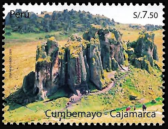 |
|
Send note to Staff
|
| Edited by KuoLC5310 - 01/07/2022 11:43 am |
|
|
Bedrock Of The Community
United States
28583 Posts |
|
|
Bolivia 2006 International Year of Deserts and Desertification Tarija Basin in southern Bolivia is filled with Neogene fluvial and lacustrine deposits of the Tolomosa Formation. It exhibits landform of gullies created by erosion of poorly consolidated rocks. 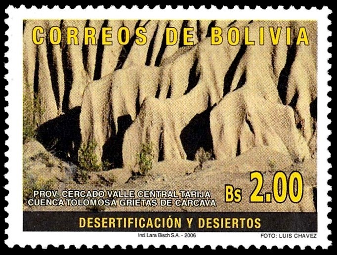 |
|
Send note to Staff
|
|
|
Bedrock Of The Community
United States
28583 Posts |
|
|
Bolivia 2010 Global Warming Chacaltaya (elevation 5421 m) is located in the Cordillera Oriental, a mountain range within the Central Andean fold and thrust belt. It comprises mainly Paleozoic sedimentary rocks. Its glacier disappeared in 2009 due in part to missing precipitation and the warm phase of El Niño. 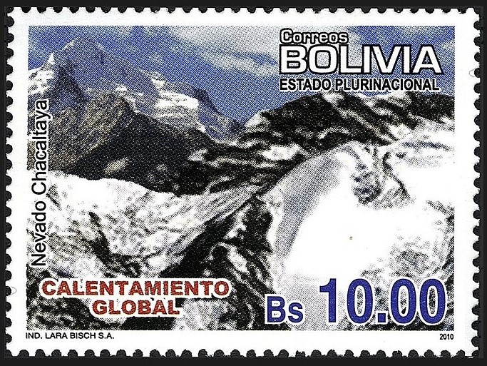 |
|
Send note to Staff
|
|
|
Bedrock Of The Community
United States
28583 Posts |
|
|
Argentina 2019 National Parks Sierra de las Quijadas National Park covers a vast, desert-like area in the San Luis province. It is known for Potrero de la Aguada, a natural amphitheater framed by red sandstone cliffs. The rock formation in this basin comprises mainly of Early Cretaceous aeolian, fluvial, and lacustrine sediments. El Leoncito National Park is located in the province of San Juan, at the foothills of the Cordillera de la Ramada. The continental crust of this Precordillera terrane broke away from Laurentia and joined Gondwana during Cambrian-Ordovician time.   |
|
Send note to Staff
|
| Edited by KuoLC5310 - 01/14/2022 12:41 pm |
|
|
Bedrock Of The Community
United States
28583 Posts |
|
|
Argentina 2002 Landscapes Cerro de los Siete Colores is one of the hills bordering the Quebrada de Purmamarca, in Jujuy Province. The rock formations in this hill include phyllite and slate (grey-green), limestone (off-white), sulphur-bearing sandstone (ochre), lead-bearing limestone (purple), iron-rich claystone (orange-red), mudstone (salmon), and manganese-bearing conglomerate (brown). 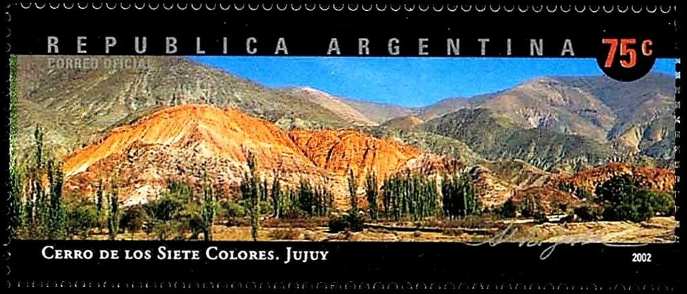 |
|
Send note to Staff
|
|
|
Bedrock Of The Community
United States
28583 Posts |
|
|
Brazil 2018 Canyons Fortaleza Canyon and Itaimbezinho Canyon are located inside Serra do Mar, a system of mountain ranges and escarpments in southern Brazil. They feature shear cliffs of Paleozoic-Mesozoic crystalline rocks cut by Rio da Pedra and Rio do Boi, respectively. 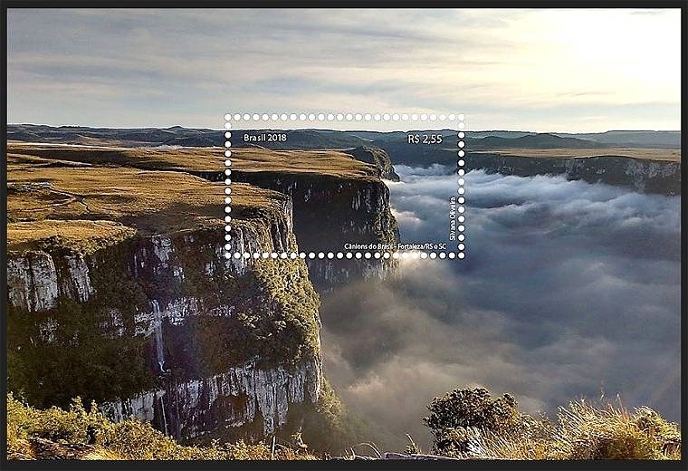 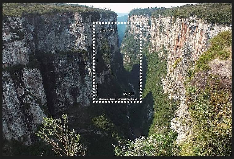 |
|
Send note to Staff
|
| Edited by KuoLC5310 - 01/21/2022 11:02 am |
|
|
Bedrock Of The Community
United States
28583 Posts |
|
|
Brazil 2014 Saint Peter and Saint Paul Archipelago Saint Peter and Saint Paul Archipelago is a group of 15 islets and rocks in the central equatorial Atlantic Ocean, sitting on the South American-African Plate boundary. It is part of Atobá Ridge, where upper mantle serpentinized mylonites outcrop as a result of the transpressional stress along the Saint Paul Fracture Zone. 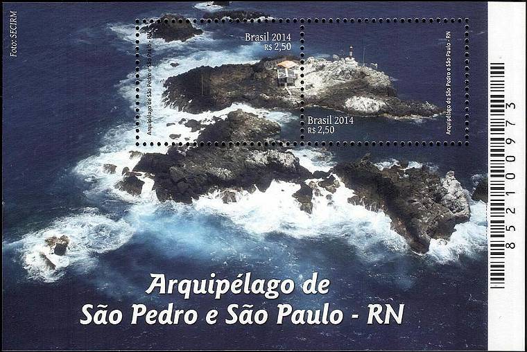 |
|
Send note to Staff
|
|
|
Pillar Of The Community
Canada
2025 Posts |
|
|
Thanks for doing this!!
I feel it's a great contribution,
Lots to be learned from not just from the stamps themselves,
But the way you do things
|
|
Send note to Staff
|
|
|
Bedrock Of The Community
United States
28583 Posts |
|
|
Guyana 2018 Landmarks of Guyana Monte Roraima (2810 m above sea level) is part of the Pakaraima, a highland within the Guyana Shield in northern South America. This and other table-top mountains (tepuis) are erosional remnants of a large Proterozoic quartz arenite plateau on top of the crystalline basement. 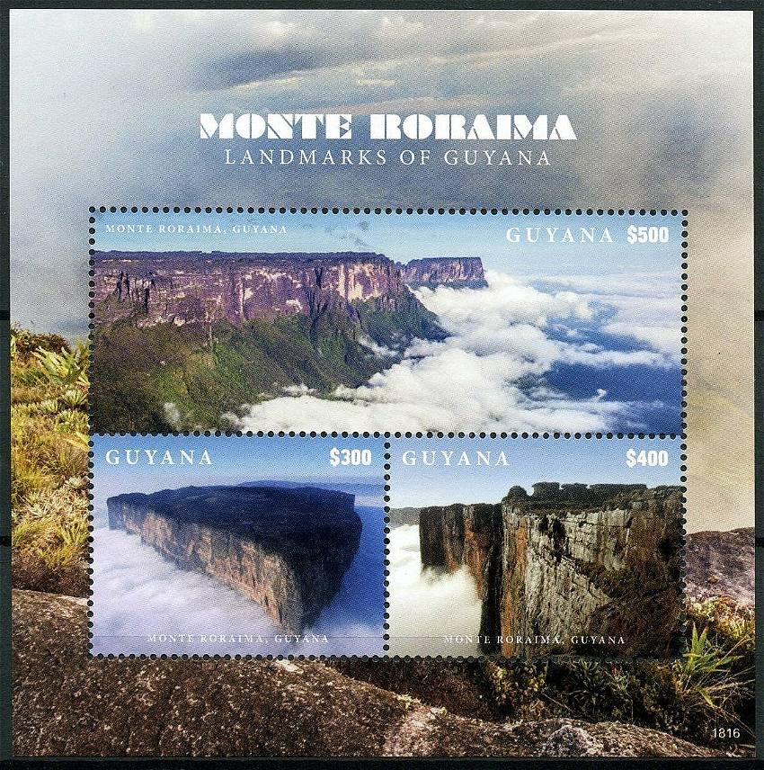 |
|
Send note to Staff
|
|
|
Bedrock Of The Community
United States
28583 Posts |
|
|
Venezuela 2006 Mountains Pico Bolivar (elevation 4978 m) is the highest peak of Cordillera de Mérida, a northeastern extension of the Andes Mountains. It comprises Precambrian metamorphic rocks. Orogeny of the Mérida Andes results from oblique convergence between the North Andes Plate and the South American Plate. 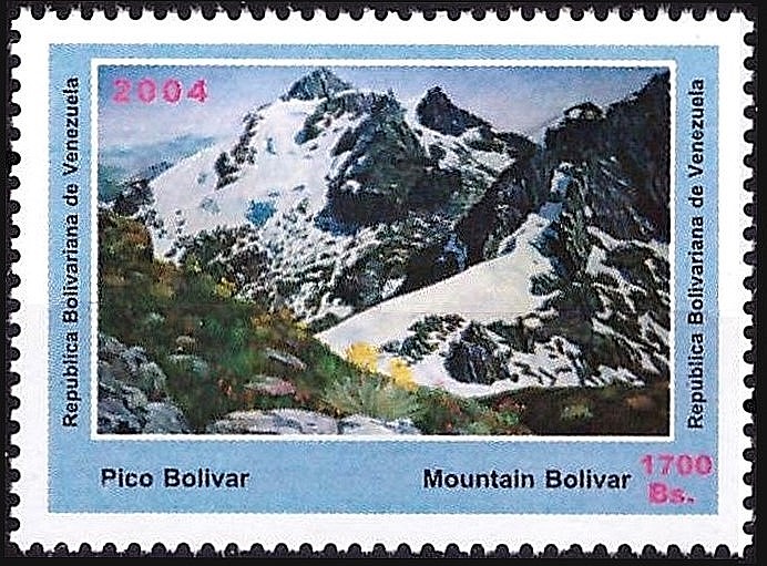 |
|
Send note to Staff
|
|
|
Bedrock Of The Community
United States
28583 Posts |
|
|
Colombia 2003 Department of Huila Tatacoa Desert covers 330 square kilometers around the town of Villavieja. Extensive erosion of Miocene fluviatile terrace deposits creates labyrinthine gullies in the landscape that can reach 20 meters deep. 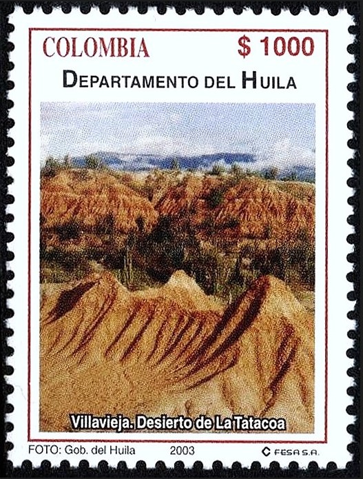 |
|
Send note to Staff
|
|
|
Bedrock Of The Community
United States
28583 Posts |
|
|
Colombia 2019 Chiribiquete National Park Chiribiquete Mountains are a group of isolated table mountains (tepuis) in the Amazon Region of Colombia. They are remnants of a Proterozoic sandstone plateau and are part of the western edge of the Guyana Shield. 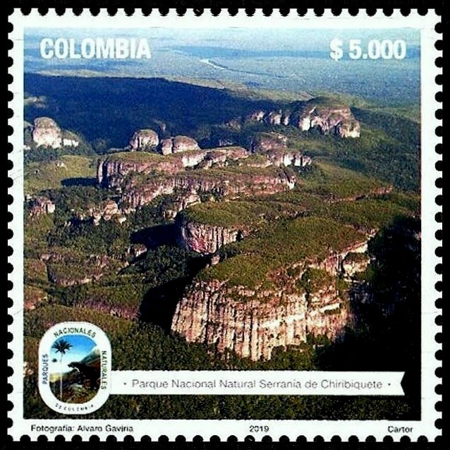 |
|
Send note to Staff
|
|
|
Replies: 341 / Views: 110,752 |
|


