| Author |
 Replies: 643 / Views: 152,233 Replies: 643 / Views: 152,233 |
|
|
|
Pillar Of The Community
7838 Posts |
|
|
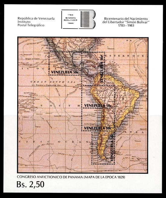
Bas S Warwick - Perhaps that is L'Île mystérieuse (Jules Verne's Mysterious Island)?  Map of Central America showing the location of El Salvador, printed by photogravure (Waterlow & Sons, Ltd.), and issued by El Salvador in 1924, Scott No. 500. - nethryk  |
Send note to Staff 
|
|
|
Pillar Of The Community
7838 Posts |
|
|
Here is a stamp depicting a wooden sculpture c. 1325-50 from Sund Church of Saint Olaf, patron saint of Faroe Islands, and an antique map (1570) of the North Atlantic ocean showing the location of the islands (in red ink), designed and combined engraved by Martin Mörck and lithography, and issued by Faroe Islands on September 12, 1995 to commemorate the 1,000th anniversary of the saint's birth, Scott No. 289, Facit No. 288. Historical note: The original map was designed by Flemish cartographer and geographer Abraham Ortelius (1527-1598), and engraved by German engraver and etcher Franz Hogenberg (15351590). Philatelic note: This stamp was a joint issue with Åland, which is also indicated in red ink on the stamp. - nethryk  |
|
Send note to Staff
|
| Edited by nethryk - 05/30/2013 1:13 pm |
|
|
Valued Member
United States
114 Posts |
|
|
Pillar Of The Community
7838 Posts |
|
|
Relief map of France, printed by photogravure, and issued by France on September 29, 1990 to commemorate the 50th anniversary of the French National Geographic Institute, Scott No. 2231, Y&T No. 2662. - nethryk  |
|
Send note to Staff
|
|
|
Pillar Of The Community
7838 Posts |
|
|
Here is an image of a stamp depicting a map of Liberia showing the locations of various counties and cities, engraved and printed by E. A. Wright Bank Note Company, Philadelphia, and issued by Liberia on December 22, 1947 to commemorate Liberia's centenary, Scott No. 306. - nethryk  |
|
Send note to Staff
|
|
|
Pillar Of The Community
Singapore
1054 Posts |
|
|
500th anniversary of the birth of Gerhard Mercator. This guy is responsible for the Mercator projection that is used in many modern maps. He was born in what is modern day Belgium, and died in what is now Germany, hence these 2 countries issued commemorative stamps on his birth anniversary. This one is from Germany. 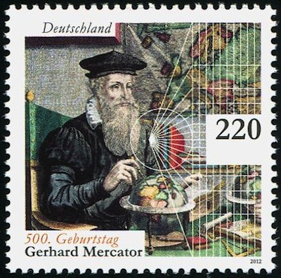 |
|
Send note to Staff
|
|
|
Pillar Of The Community
7838 Posts |
|
|
Map of Argentina and its sector of Antarctica, designed by Argentinian artist Héctor Amadeo Viola (1934- ), printed by lithography, and issued by Argentina on September 24, 1960 to publicize the national census, Scott No. 719. - nethryk  |
|
Send note to Staff
|
|
|
Pillar Of The Community
Singapore
1054 Posts |
|
|
This miniature sheet released in 2012 by Laos for the 9th Asia-Europe Meeting Summit held in Vientiane shows the country map and the provinces. The stamp in it shows the Asia map with South-east Asia highlighted. 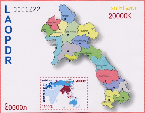 |
|
Send note to Staff
|
|
|
Moderator

United States
4788 Posts |
|
|
Pillar Of The Community
7838 Posts |
|
|
Map of the Caribbean Sea and northern South America, showing the location of British Guiana (now Guyana), engraved and printed by Waterlow & Sons, Ltd., and issued for use in British Guiana on December 1, 1954, Scott No. 257. - nethryk  |
|
Send note to Staff
|
|
|
Pillar Of The Community
Singapore
1054 Posts |
|
|
This Singapore 1980 $1 stamp has the map of early days of South-east Asia. It was released for the 1980 London International Stamp Exhibition. Scott 351. 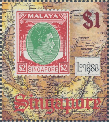 |
|
Send note to Staff
|
|
|
Pillar Of The Community
Singapore
1054 Posts |
|
|
This Singapore 1980 10-cent stamp has in the background the map of the trading town set in early-day Singapore which became a renowned international city. Scott 349. 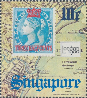 |
|
Send note to Staff
|
|
|
Pillar Of The Community
Singapore
1054 Posts |
|
|
This miniature sheet released by Singapore in 1983 for the Bangkok International Stamp Exhibition has in the background the map of South-east Asia. The map is again used in the design of the 35-cent stamp. Scott 425a. 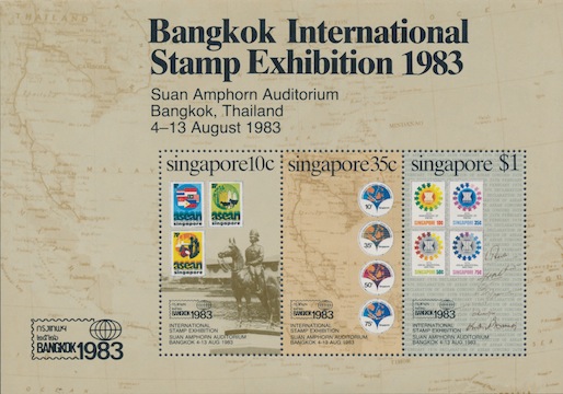 |
|
Send note to Staff
|
|
|
Pillar Of The Community
7838 Posts |
|
|
Here is an image of an airmail stamp featuring a map of Tahiti, and inset portraits of Swedish naturalists Daniel Carlsson Solander (1733-1782) and Anders Erikson Sparrman (1748-1820) who accompanied British explorer Captain James Cook on voyages to the South Seas, designed and engraved by Pierre Forget, and issued for use in French Polynesia on August 28, 1986 to publicize the STOCKHOLMIA '86 philatelic exposition, Scott No. C219. - nethryk  |
|
Send note to Staff
|
| Edited by nethryk - 07/22/2013 09:37 am |
|
|
Pillar Of The Community
7838 Posts |
|
|
Here is an image of a stamp featuring looping lines superimposed over a map of Europe, designed and engraved by Albert Decaris, and issued by Monaco on April 28, 1967 to publicize the Comité Intergouvernemental pour les Migrations Européennes (CIME), Scott No. 668. - nethryk  |
|
Send note to Staff
|
|
|
Replies: 643 / Views: 152,233 |
|