| Author |
 Replies: 13 / Views: 2,297 Replies: 13 / Views: 2,297 |
|
|
Rest in Peace
Netherlands
153 Posts |
|
|
In a recent thread I noticed there are several members who make their own maps. So I thought it might be interesting to start a thread on map making. To show some examples of those maps and to share and discuss the techniques used. So please if you make maps and care to share them do so in this thread. Obviously I'll start off the thread my self. I make my maps in Powerpoint. Maybe not the most sophisticated tool for map making but I was thoroughly familiar with Powerpoint when I started map making and it gets me were I want to be. I publish the maps on my website - www.stampworldhistory.com - in PNG. I am not entirely happy with the way they come out yet - they become a bit fuzzy when resized. (Suggestions on how to tackle this are most welcome!) When blown up to full format they are just fine though. For more complex maps I add a link to the map in PDF so that people can zoom in as much as they want without loosing quality. Here's an example: 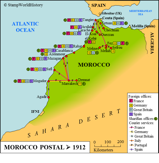 |
|
Send note to Staff
|
| Edited by SWH - 11/27/2015 07:50 am |
|
|
|
|
Pillar Of The Community
United States
978 Posts |
|
|
Hi SWH Here is some information on different types of image files and their advantages and disadvantages: http://www.scantips.com/basics09.htmlFor lossless compression I would use TIF, or TIFF. The files are larger but you do not lose anything from the original, theoretically. However, the article above states that TIFF cannot be shown on Web pages. So that leaves that format out, unless new software does allow TIFF files. Jerry B |
Send note to Staff 
|
| Edited by jbcev80 - 11/27/2015 06:45 am |
|
|
Pillar Of The Community
United States
772 Posts |
|
|
Rest in Peace
United States
4052 Posts |
|
|
Jerry:
There is a compression option for TIF - not every software program will offer it - but, if you are on the receiving end, you will have to do the math (or learn how to read the headers) to know whether/not the image was compressed.
BMP is never compressed, and never has a header.
SWH:
Q/ Does 'foreign office' always mean a dedicated facility (room, desk, cash drawer) staffed by a direct employee?
Or, in the manner of correspondent banks, did it mean that mail would be handled by someone?
Q/ Does 'courier services' mean ... that markings exist? advertisements? route maps?
Q/ Is that map respective of philately, or your personal holdings?
Some of us may know little less than you about the standards that are met in these designations ;)
Cheers,
/s/ ikeyPikey |
|
Send note to Staff
|
|
|
Moderator
1589 Posts |
|
|
Quote:
I usually just steal my maps from the Internet Or make them with Google Maps. |
|
Send note to Staff
|
|
|
Pillar Of The Community
United States
2423 Posts |
|
|
SWH, quite interesting! What a wealth of information!
If I may make a suggestion, I would label Germany or Great Britain differently. 'D' for Germany perhaps or 'B' for Great Britain. |
|
Send note to Staff
|
|
|
Rest in Peace
Canada
5701 Posts |
|
|
Nice map SWH, as are your others on your website.
I have mentioned in other threads, I make mine in AutoCAD. It is a vector based program so there is no lossless, as I can scale the map and change the text size in any number of layouts. Also, it has great layer features.
After that I can export to JPG, PNG PDF, etc. However, I often add color in the JPG as it is easier to do so than in AutoCAD.
Good questions IkeyPikey. I'd like to know those answers too. |
|
Send note to Staff
|
|
|
|
Pillar Of The Community
United States
978 Posts |
|
|
Hi ikeyPikey
Thanks for the info. I have the document that I referred to and a format document because I was doing some programming with image files. So if I needed it I could read the headers.
Again thanks for the info.
--------------------------------------------------
SWH:
Interesting map of Morocco. In the 1950's I was stationed in Rabat with the US Air Force for a year. They sent me because I spoke French. At that time there were 2 Moroccos, Spanish and French. I have been to every place on your map from Rabat to Agadir and to the Meknes Area. I never got to Tangier since it, at that time, was off limits to Air Force personnel.
Relative to my collecting interest. When will you do Colombia, Ecuador and Venezuela? The web site is interesting and well done.
Jerry B |
|
Send note to Staff
|
|
|
Rest in Peace
Netherlands
153 Posts |
|
|
Jerry 1) Thanks for the link, I've bookmarked it for future reference. Actually PNG as export format from Powerpoint works just fine as long as the PNG image is presented on the web full size. The problems start when I want to present it in a smaller - or bigger - size. The scaling options in Wordpress produce a fuzzy result - which is a known problem in Wordpress. 2) I'll be working on your countries within the next few weeks. I am now working on Peru and have touched upon Ecuador and Colombia in that context. Complex! But therefore an interesting challenge. BeeSee Thanks. I guess scaling the original as you say you do in Autocad would solve my problem but that is difficult in Powerpoint. Scaling the shapes in the map works fine but I have not yet found a way to properly scale the text along with the shapes. When using the autoscale option for text boxes things get screwed up. The only option would be to scale the shapes and then choose a new font size for each indiviual text box and next realign the text boxes. Which would mean too much work. ikeyPikey For more info please refer to the page I took this map from: http://www.stampworldhistory.com/co...ica/morocco/. The map is meant to reflect the postal situation in Morocco up to 1912, not the status of my personal collection - if that is what you mean by 'personal holdings'. |
|
Send note to Staff
|
| Edited by SWH - 11/27/2015 4:20 pm |
|
|
Pillar Of The Community
United Kingdom
8580 Posts |
|
|
Pillar Of The Community

United States
663 Posts |
|
|
Powerpoint allows you to save images in .JPG format. That is the most common format used for web images. If I need to enlarge or trim an image I use SNAGIT from TechSmith: https://www.techsmith.com/ SnagIt is an inexpensive and easy to use image capture program. Cost about $35 on line. Available for download. |
|
Send note to Staff
|
|
|
Moderator
United States
12330 Posts |
|
|
Bitmap image formats (i.e. jpg, png, etc.) will always be problematic when resized, this is independent from what application is being used. Bitmaps images comprised of 'pixels', when resized the software simply changes the image by adding/removing more pixels. On the other hand, raster images (i.e. dwg, dxf, crd etc.) are not made up of pixels but are rather coordinates. When resized, the computer simply does the math. Raster images will resize perfectly every time.
PowerPoint does not support raster images, either bringing them into the PowerPoint or when exporting out of PowerPoint. But note there are some things that you can do with bitmap images that will make resizing a bit less ugly. First, I would export using the Windows metafile (wmf) format. While a bitmap format, this kind of image file has some math in it to help with proper resizing. Wmf is not a great internet image format so I would export it, resize to desired size, and then save it is a JPG or PNG for publishing on the web.
Don
|
|
Send note to Staff
|
|
|
Pillar Of The Community
United States
978 Posts |
|
|
Hi SWH Quote:
I am now working on Peru and have touched upon Ecuador and Colombia in that context. Complex! But therefore an interesting challenge. You are going to find that the history for Venezuela, Colombia, Panama (as a state of Colombia), Ecuador, Peru and Bolivia are going to overlap somewhat. This is due to the campaigns of Simon Bolivar. Look at maps of Gran Colombia and you will see why the overlap in history. Jerry B. |
|
Send note to Staff
|
|
|
Rest in Peace
Netherlands
153 Posts |
|
|
GeoffHa:
Thanks for your appreciation.
Oldguy, 51studebaker:
Thanks for your suggestions. I will definitely experiment!
jbcev80:
I think 'overlap somewhat' is an understatement - it's a tangle. But I like it. South America is a continent that from western Europe we are not very familiar with, writing these profile is a great way to catch up on the history of this part of the world. BTW: any suggestions for online resources that might help understand the history of these countries would be greatly appreciated. |
|
Send note to Staff
|
|
| |
Replies: 13 / Views: 2,297 |
|


