Dear Bobby and erliaz,
Quote:
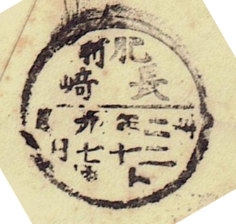
The name of the city is the second line in each of these postmarks. I'm guessing that the top line is the specific post office, but I can't make out either one.
The top line is the name of the province, i.e. the administrative divisions of the modern prefectures. It is literally called as "Old Country Name" in Japanese. I personally do use often this map of provinces from Wikimedia, which lists all the provinces in Japanese and their pronunciations in english;
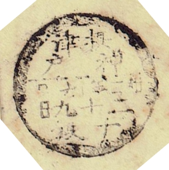
https://upload.wikimedia.org/wikipe...japanese.gifThe second row is the post office. The third row, right after the horizontal line is the year/month, the forth row the day, and the last row (if present) denotes the delivery (which may vary from once a day to as many as 19 deliveries a day!) Be aware that, in those days, people wrote from right to left (as opposed to the present way).
(Bobby, I am pleased to hear that you've managed to figure out the dates !!!

)
So the datestamp (Maru-Ichi type, literally meaning Bisected circle type) of Nagasaki would read as;
Hizen / Nagasaki / Meiji 32 September / 27th / "To" delivery (7th delivery)
and the Kobe would read as ;
Settsu / Kobe / Meiji 32 September / 29th / "Chi" delivery (8th delivery)
- Hironobu