| Author |
 Replies: 34 / Views: 5,897 Replies: 34 / Views: 5,897 |
|
Bedrock Of The Community
Australia
38679 Posts |
|
|
|
I am reading the Carnatic Wars.
I read about the pirate fort at Gheriah,
anyone know where that may be?
I am asessing somewhere along the east coast between
Kolcatta and Pondicherry, probably far North nearing
Kolcatta.
Google was not my friend.
Thanks
|
|
Send note to Staff
|
| Edited by rod222 - 11/02/2010 02:07 am |
|
|
|
|
Pillar Of The Community
United States
7081 Posts |
|
|
See if you can make sense of this, from the old India Directory, Sailing Directions to and from the East Indies:
RETTNA-GERIAH, or FALSE GERIAH, in lat. 17° 2' N., is a neck of land fortified all over, and forms the South side of the bay last mentioned: the landingplace is on the North side the fort, where there seems to be shelter for small vessels during the S.W. monsoon. When viewed at a distance, this place appears insulated,* flat and level like a wall, excepting the northern part, which is highest and covered with trees.
On the South side this neck of land, a large bay is formed, from wheuce a river, capable of receiving small vessels over its bar at high water, extends a great way inland, having on the North side the entrance a small round tower on the brow of a hill. At the South extremity of this bay there are some rocks above water, about half a mile from the shore, and a little farther southward, a remarkably large Banyan Treet may be discerned on a hill near the sea. To the southward of this, and 8 miles from Rettna-Geriah, there is a small bay on the South side of a point of land.
RADJAPOUR FORT, in lat. 16° 47' N., bears from Rettna-Geriah about S. by E., distant 5 leagues, and is situated on a barren hill, on the North side of the river, which trends to the north-eastward. The hills on the South side are covered with trees, and close by the river, on this side, stands a remarkable white pagoda; hence Radjapour Point was formerly called Pagoda Cape.
VIZIADROOG or GERIAH HARBOUR was surveyed in 1844, by Lieut. Montriou, who places the Fort Flagstaff in lat. 16° 34' N. The Point on which the Fort stands forms the South side of the entrance, and is high and bluff, bearing South from Radjapour Point 5^ leagues, and is 27^ miles East of Bombay Castle. This is a projecting part of the coast, the land receding both to the northward and southward. There is no bar at the entrance, the depths being from 4 to 6 fathoms, and from 2 to 3 fathoms inside, at low water; the rise of tide is about 9 feet.
Lieut. Montriou remarks, that during his stay the westerly and south-westerly breezes occasioned a very heavy swell in the harbour, and at times a heavy surf on its N.E. side, rendering it dangerous for boats to land, but on the Fort side of the harbour a landing may be safely effected at all times. A good anchorage in 3 fathoms may be found with the Fort Flagstaff bearing about S.W. by W. 500 yards from the wall of the Fort, and in the Road in 6 fathoms N.W. of the Fort. Variation 0° 19' E., 1844. |
Send note to Staff 
|
|
|
Bedrock Of The Community
Australia
38679 Posts |
|
|
Thanks Collin (fascinating) I'll check my coordinates. That old india directory sounds interesting. This may be an exciting study for LondonBus the flag on the fort here at Geriah 1756 is that a rare occurence of the George Cross flag for Britain? Source JH Parry : Trade and Dominion 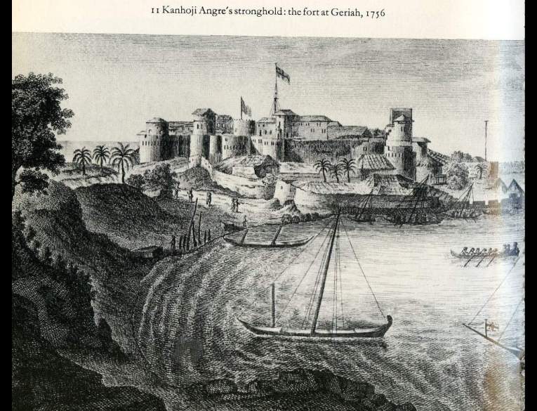 |
|
Send note to Staff
|
|
|
Pillar Of The Community
United States
7081 Posts |
|
|
Pillar Of The Community
United States
7081 Posts |
|
|
Admiral Watson took the fort from Tullagee Angria in 1806...could it have been under British control as early as 1756, before becoming a pirate HQ? |
|
Send note to Staff
|
|
|
Pillar Of The Community
2664 Posts |
|
|
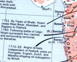
garia is a place in west bengal near Calcutta or shall I say kolkata
and cjd the ratna giri you are looking for s in maharashtra and they have fabulous alphonsa mangoes yum yum 6 more months to go |
|
Send note to Staff
|
|
|
Bedrock Of The Community
Australia
38679 Posts |
|
|
It was finally taken in 1756, not sure about Admiral Watson I think it involved HMS Kingfisher. I still havn't found where it is located yet  but have found substantial information in the "Oriental herald" of 1829 I'll email you the paper Collin (30Mb) Probably the biggest problem "Geriah" being an Anglicised name looking nothing like the name on a current map --------------- Donning the thinking cap.. At that time, britain was there under a defacto relationship with the East India Comapny. ( Control without the risk and expense of Government) The flags on the ships were maybe British or French East India jacks. Flags of the East India Company: 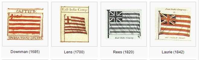 in keeping with this stamp design of Singapore: 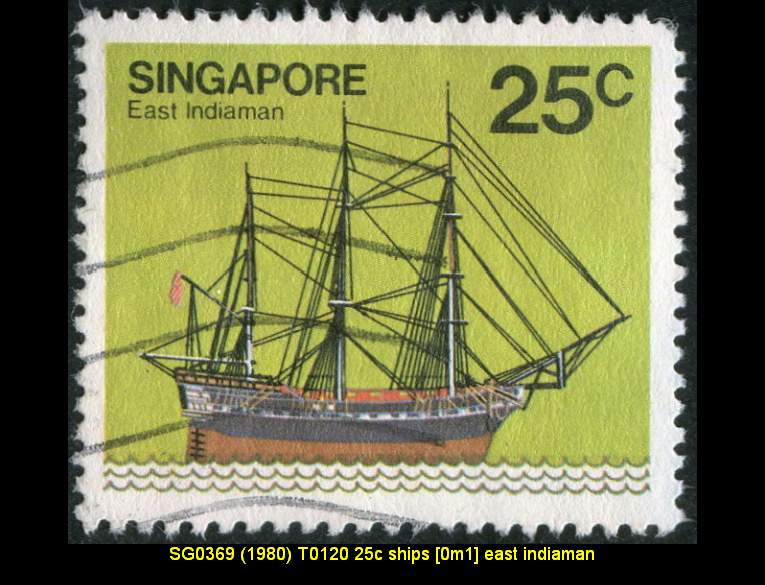 |
|
Send note to Staff
|
| Edited by rod222 - 11/02/2010 04:17 am |
|
|
Bedrock Of The Community
Australia
38679 Posts |
|
|
Anybody aware of how I can send a 30Mb file to someone,
when my IP limit is 25Mb?
Thanks
|
|
Send note to Staff
|
|
|
Pillar Of The Community
United States
7081 Posts |
|
|
Bedrock Of The Community
Australia
38679 Posts |
|
|
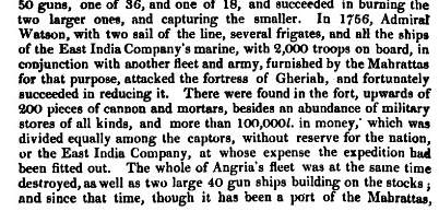
Yes confirmed Collin, somewhere south of Bombay
Admiral Watson captured it in 1756, with 2 sail of the line,
several frigates, and <all> of the East India Marine,
with 2000 troops aboard.
They sacked the place and recovered 100,000 "l" (currency unknown)
divided equally among all the troops, England or the East India
company receiving nothing but future free passage along the coast.
|
|
Send note to Staff
|
|
|
Pillar Of The Community
Australia
3547 Posts |
|
|
The invaluable Murray's Handbook for Travellers in India ... (16th edition, 1949) says
'Steamers (twin-screw and oil-driven) of the Bombay Steam Navigation Company ("Shepherd Company") ... sail from the Alexandra Dock, Ferry Wharf, for Panjim (Nova Goa) daily, carrying the mails, and calling at Ratnagiri and Vijayadrug, an old Angria stronghold, taken by Clive in 1756 (daily service also to Vijayadrug).'
Murray mentions Admiral Watson's grave in the Church of St John in Calcutta: '... the tomb of Admiral Charles Watson, who, with Clive, retook Calcutta (died 16th August 1757). It has a large square base, supporting an obelisk, inscribed to his memory. Close by is the tomb of "Billy Speke," a midshipman on the Admiral's flagship, the Kent, who "lost his leg and his life" at the capture of Chandernagore (Fort Orleans) on 24th March 1757.' |
|
Send note to Staff
|
|
|
Pillar Of The Community
Australia
3547 Posts |
|
|
Quote:
They sacked the place and recovered 100,000 "l" (currency unknown) £s? |
|
Send note to Staff
|
|
|
Bedrock Of The Community
Australia
38679 Posts |
|
|
Bedrock Of The Community
Australia
38679 Posts |
|
|
Ah! all making sense now.
VIZIADROOG or GERIAH HARBOUR = "severndroog" (sic) = and calling at "Vijayadrug"
Many names of the small, and low (nearly idistinguishable) Island
near the fort at Gheriah.
The Angrian pirates had this island heavily fortified as well.
|
|
Send note to Staff
|
|
|
Pillar Of The Community
United Kingdom
658 Posts |
|
|
Hi Rod - regarding the 30mb file, you can upload the file to an FTP server and then get the person to download it from there (Contact me if you want to use my ftp server). You can also compress the file and split it? |
|
Send note to Staff
|
|
|
Bedrock Of The Community
Australia
38679 Posts |
|
|
Replies: 34 / Views: 5,897 |
|