| Author |
 Replies: 17 / Views: 3,273 Replies: 17 / Views: 3,273 |
|
Pillar Of The Community
United States
1804 Posts |
|
|
Let's test your powers of deduction. I found this real photo postcard in a bargain box and really liked the picture. I'm pretty sure this is from WWI, but there's nothing that specifically identifies the soldiers' nationality. Can anyone help identify them by their uniforms or something else in the photo?  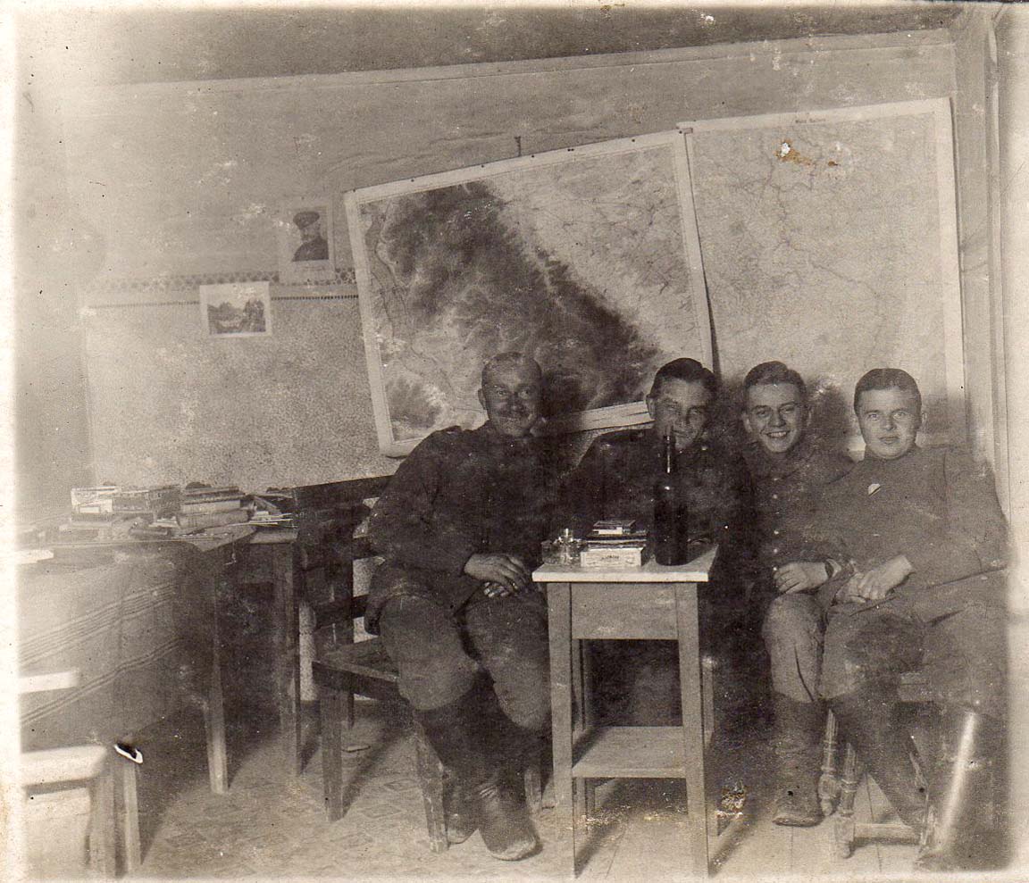 |
|
Send note to Staff
|
| Edited by GregAlex - 09/17/2017 01:31 am |
|
|
|
|
Pillar Of The Community
United States
2941 Posts |
|
|
Pillar Of The Community
1151 Posts |
|
|
Hi, how about a scan of the reverse side? Might or might not help, but worth a try!
Can anyone make out what is on the left wrist on the person second from right?
Stampmaster |
Send note to Staff 
|
|
|
Pillar Of The Community
United States
572 Posts |
|
|
Assuming the maps on the wall are of their operations area, can you make out anything on them? Might narrow the choice of the troops nationality. |
|
Send note to Staff
|
|
|
Pillar Of The Community
France, Metropolitan
3744 Posts |
|
|
Pillar Of The Community
United States
1804 Posts |
|
|
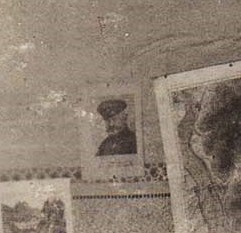
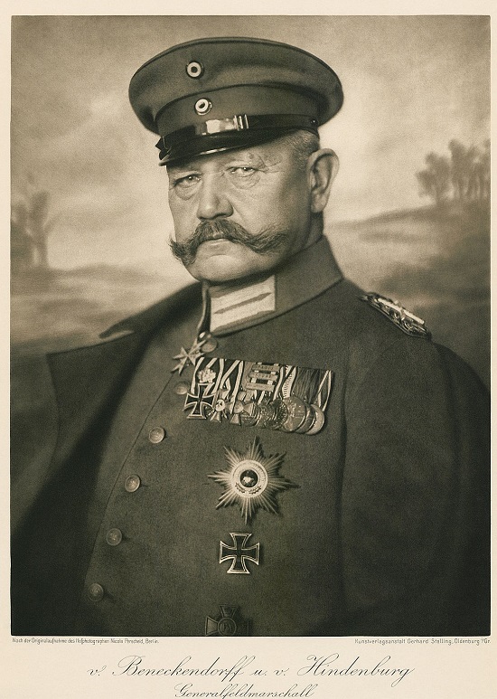
Stampmaster, the back is blank, so no help there. I believe that's a wristwatch that one soldier is wearing. I think the Hindenburg portrait is the key, though -- that sure looks like a match to me! So these are probably German officers. For what it's worth, here is an extreme close-up of the top of the right map. Anyone want to take a stab at the territory? 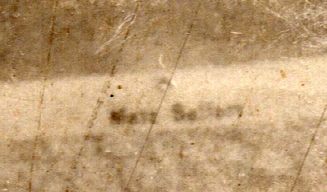 |
|
Send note to Staff
|
| Edited by GregAlex - 09/18/2017 12:21 am |
|
|
Pillar Of The Community
United Kingdom
1255 Posts |
|
|
The first word looks like Metz, north of Nancy in NE France. This would make the large river The Moselle. The map on the right clearly shows the border of Luxembourg. As for a date, we now have to start looking at German campaigns in this area, although an early date in WW1 is highly likely. Some homework for a Monday morning! |
|
Send note to Staff
|
| Edited by Tim H - 09/18/2017 02:11 am |
|
|
Pillar Of The Community
United States
3487 Posts |
|
|
Neat item. This past weekend, my wife and I went to a strip of antique shops in a small town nearby. Not one of them had any postcards. I was disappointed. |
|
Send note to Staff
|
|
|
Pillar Of The Community
1375 Posts |
|
|
Perhaps it reads "Metz Saalburg", and you can find more information about the Saalburg in the internet in English (in German there is: http://www.taunus-zeitung.de/lokale...690,904314). But you can check if the words are right. The line must be the border between Germany and France to that time (1871-1918). |
|
Send note to Staff
|
| Edited by stamperix - 09/25/2017 3:48 pm |
|
|
Pillar Of The Community
United States
2941 Posts |
|
|
The map on the right is definitely of the area around Metz. The area at the top between the forking borders is Luxembourg. Compare the borders shown in the map to the yellow, pre-war borders shown here. 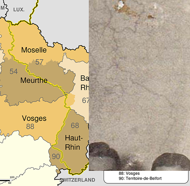 |
|
Send note to Staff
|
|
|
|
Pillar Of The Community
United States
1804 Posts |
|
|
Great sleuthing! That certainly looks like the French-German border to me. The left map looks like more specific topography. |
|
Send note to Staff
|
|
|
Bedrock Of The Community
Australia
38679 Posts |
|
|
Quote:
The map on the right is definitely of the area around Metz. The area at the top between the forking borders is Luxembourg. Compare the borders shown in the map to the yellow, pre-war borders shown here.
You never fail to amaze me, Postmaster. |
|
Send note to Staff
|
|
|
Pillar Of The Community
United Kingdom
1255 Posts |
|
|
The map on the left is really, really bugging me. I first thought it was the River Moselle but I'm sure that it isn't. Next thoughts were the River Rhine between Freiburg and Colmar, maybe even Mulhouse, as this is consistent with my thoughts of an early date for the photo and the campaigns associated with the map on the right (Alsace-Lorraine, Saar). However, the geography of the left-hand map doesn't seem right. The width of the river makes it look like quite a small scale map but (1:50,000 or 1:25,000) but the colour shading makes it look like a much larger scale, 1:100,000 or more, in which case the river is waaaay too wide.  Does anyone know what scale the German military topographic maps were? Any sleuths good on German physical geography? |
|
Send note to Staff
|
|
|
Pillar Of The Community
United States
939 Posts |
|
|
My guess is Metz Salzburg. Metz, France and Salzburg, Austria. Distance between the two is about 325 miles, or so google says. |
|
Send note to Staff
|
|
|
Pillar Of The Community

United States
1951 Posts |
|
|
The right map certainly looks to be in the Luxembourg to me. The boots and picture appear to be German.
Jack Kelley |
|
Send note to Staff
|
|
|
Pillar Of The Community
United States
2941 Posts |
|
|
The left map is a topographical map of the area east of the Meuse river south of Verdun (the so-called St Mihiel salient). This is an area that was fairly static from 1914 until the St Mihiel offensive in September 1918. The lines at left are the Meuse river valley. To the right of the dark topo area you can see towns marked on the map that correspond to existing towns on a modern map. The town with a name marked at the upper edge of the dark area is Manheulles. Compare to a modern Google maps topo. 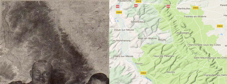 |
|
Send note to Staff
|
|
| Edited by PostmasterGS - 09/26/2017 11:04 pm |
|
|
Replies: 17 / Views: 3,273 |
|